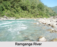
 The Ramganga River is divided into Ramganga West River and Ramganga East River. Both the rivers originate in Indian state of Uttarakhand.
Ramganga West River
Ramganga West River originates in the district of Pauri Garhwal from the Doodhatoli ranges. This river is situated at an elevation of about 130 m (427 ft). It has a drainage basin of about 30,641 square kilometers (11,831 square miles). It enters the district of Nainital, before re-entering its parent district, Pauri Garhwal. The river then journeys through Patali Dun and then moves southeast before entering the plains near Kalagarh Fort. It then passes through Moradabad. The Mandul, Palain and Sona are known to be the other tributaries amalgamating with Ramganga West. Ramganga passes through several places. Some of the important places traversed by Ramganga West are Taal, Chaukhutia, Bhagoti, Masi, Bhikyasen etc. These locations come under Kumaun region. The mouth of Ramganga West is Ganges, near Ibrahimpur in Uttar Pradesh. Ramganga West River is a tributary of the river Ganges. Moradabad, Bareilly, Badaun, Shahjahanpur and Hardoi cities of Uttar Pradesh is situated on the banks of Ramganga West.
Development of Ramganga West River
Development of Ramganga West River took place in terms of a dam called the Ramganga Dam. This dam came into existence as a part of the irrigation and hydroelectric project namely, Ramganga Multipurpose Project. This dam is defined as an earth and rock-filled embankment dam. The Ramganga River is called it"s impounds. Construction of the dam commenced in the year 1961 and was completed in the year 1974. It is located near about 3 km (2 mi) upstream of Kalagarh in Pauri Garhwal district in Uttarakhand. It can also be said to be situated within the Jim Corbett National Park. It has a height of about 128 m (420 ft), length of about 715 m (2,346 ft) and dam volume of about 10,000,000 m3 (13,079,506 cu yd). It has a catchment area of about 3,134 km2 (1,210 sq mi) and surface area of about 55 km2 (21 sq mi). The volume of the dam is about 10,000,000 cubic m (13,079,506 cu.yd). Its spillway capacity is about 8,467 cubic m/s (299,009 cu ft/s). The dam`s spillway is controlled by five gates and has a maximum discharge of about 299,009 cu ft/s. Below the dam is a system of over 6,300 km (3,915 mi) of canals supported by three barrages and about 82 km (51 mi) of main feeder canal.
It functions to support a 198 MW power station. The three generators in the power station were commissioned in December 1975, November 1976 and March 1977. It provides water to farmland of about 57,500 ha (142,086 acres) for irrigation. It also plays a vital role in controlling floods.
Significance of Ramganga West River
The Ramganga West River along with its significant tributaries Sonanadi, Palain and Mandal is recognized as a prominent hydrological resource of the Corbett National Park. The river was considered to be so important for the survival of the entire range of flora and fauna species that it was named Ramganga National Park for a brief period from 1954-1957. The park was later named as Corbett National Park. These mighty rivers are known to control the biodiversity of the National Park. It is close to Ramnagar, (which is a small town and municipal board in the Nainital district) that the Ramganga passes by the Corbett National Park, from where it descends upon the plains.
Festival Celebrated on the Banks of Ramganga West River
The banks of the Ramganga West witness the celebration of an annual festival of Ganga Dassahra. More specifically, this festival is celebrated in Chaubari village near Bareilly during the months of September and October.
Ramganga East River
Ramganga East River originates in the Pithoragarh district of Uttarakhand from a glacier named, Namik Glacier and journeys towards the east. The river is joined by many small and big rivers and it finally amalgamates with the river Sarju at Rameshwar near the Ghat of Pithoragarh. The Sarju also amalgamates with the Kali (Sharda).
Related Articles:
Water Resources in India
Indian Rivers
Coastal Rivers
Himalayan Rivers
Deccan Rivers


