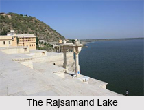
 Constructed in the 17th century, the Rajsamand Lake is located near the town of Rajsamand in the state of Rajasthan in India. This lake owes its existence to Maharana Raj Singh, following whose orders the lake was built in 1662. More specifically, the digging of its foundations began on January 1, 1662. Ranchod Rai, the elder son of Purohit Garibdas, the Royal Priest, laid the foundation stone on April 17, 1665. Construction of the actual dam on this lake began on January 14, 1676. It is also known as Rajsamudra Lake. A long Sanskrit inscription, dated 1675-1676 is a special feature of the Rajsamand Lake. This inscription is carved on twenty-seven white marble slabs. The history of Mewar is inscribed in 1017 stanzas which are known as `Raj Prasasti`. It has also been recognized as one of the longest etchings in India. It is one of the five popular lakes of Mewar.
Reasons for the Construction of the Rajsamand Lake
The Rajsamand Lake was constructed with a dam. It was built as a helping hand to the local farmers and victims of a widespread drought and famine in 1661. More specifically, provision of employment to these victims and canal irrigation to local farmers were the prime purposes behind the idea of creating this lake. Thus, this lake is also defined as the oldest known relief work in Rajasthan. As estimated, this project is known to cost almost 4 million rupees.
Geography and Hydrography of the Rajsamand Lake
As estimated, the Rajsamand Lake is about 4 miles (6.4 km) in length, approximately 1.75 miles (2.82 km) in breadth and about 60 feet (18 m) deep. Located about 66 km in the north of Udaipur, this lake is situated between two cities of Rajasthan, namely, Rajnagar and Kankroli. It was built across the Gomati, Kelwa, and Tali rivers. It has a catchment area of approximately 196 sq mi (510 km.sq.). River Gomti is the main supplier of water to Rajsamand Lake.
This lake is known to be adversely affected by a severe condition called drought. As a result, this lake dried up several times and disappeared. In 2000, after drought deprived the lake of its water, what was evident from the sight of the lake basin was a surface of dried, cracked mud. Even after the late monsoon, in the following year, which acted as a blessing for the lake and partly refilled it, the water level remained significantly low in the lake.
Embankment on the Rajsamand Lake
The embankment on the Rajsamand Lake was built at its Kankroli (southern) end. It is 183 metres in length and 12 metres high. This huge embankment is made of white stone and has terraces of large marbles. It has stone ghats (steps) leading down to the water`s edge.
This embankment is graced by ornamental arches and pavilions. Princess Charumati, from another branch of the Sisodia family, is known to commission these arches and pavilions. She commissioned them in gratitude to Maharana Raj Singh I, who married her to prevent her marriage to Mughal Emperor Aurangzeb. The weighing arches popularly known as the five toranas can be seen here. They are located where Raj Singh and his successors performed the event called Tuladan. This event was conducted for the welfare of the people. In this event the prince was weighed in gold and jewels. Its cash value was distributed among Brahmans. This cash was also utilized to construct temples and tanks for the people.
The colonnaded pavilions are exquisitely carved and decorated with depictions of the sun, chariots, gods, dancing girls and birds. These nine pavilions are popularly known as the `Nauchowki`.
History of the Rajsamand Lake
In the late 17th century, a desperate battle was fought in the Rajsamand district between Mewar and the Mughal emperor, Aurangzeb. During this battle, the Rajsamand Lake was also unsafe. The dam on this lake was defended by Anand Singh, who was an officer in the Mewar army. He fought with a small force against the Mughals and died there. Also, during World War II, Rajsamand Lake was used as a seaplane base by Imperial Airways for about 6 years.
Related Articles:
Lakes of India
Water Resources in India
History of Rajasthan
Tourism In Rajasthan
Geography of Rajasthan
Heritage Hotels in Rajasthan
Districts of Rajasthan


