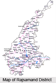
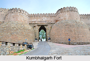
 Rajsamand district, carved out from erstwhile Udaipur district, was constituted on 10th April, 1991, and named after the famous lake "Rajsamand" built by Maharana Raj Singh. Kankroli, Rajnagar, Charbhuja, Nathdwara, Bhim, Railmagra, Kelwara, Amet and Deogarh are some of the major towns of the district. Total population of the Rajsamand district is 9, 87,024 of which 4, 93,459 are male and 4, 93,565 female. Rajsamand is quite rich in its history, religion, culture and mining industries. Among famous places of tourist interest are Kumbhalgarh - the birth place of Maharana Pratap, Haldighati the famous battle field, Shrinathji temple of the chief deity of Vaishnav religion, Dwarikadheesh, Charbhuja and many Shiva temples. Rajsamand is very well known for its marble production, as the largest producing district as well as the largest single unit in the whole country. Rajsamand also saw the vicissitudes of the freedom struggle between Tantya Tope and the British troops at `Rakamgarh ka chhapar` in 1857.
Location of Rajsamand District
Rajsamand is situated 67 Kms north of Udaipur and 352 Kms south of the state capital - Jaipur on National Highway 8. Rajsamand is located between latitudes 24 degrees 46 minutes to 26 degrees 1 minute North and Longitudes 73 degrees 28 minutes to 74 degrees 18 minutes East. Rajsamand district is surrounded by Ajmer district in the North, Pali district in the West, Udaipur district in the South and Bhilwara district in the East.
 Geography of Rajsamand District
The district covers a total area of 4550.93 Sq. Kms, which is 1.33 percent of the state of Rajasthan. It is located at a height of 532.50 metres above sea level. The district receives an average rainfall of 794 mms. Geographical area in the district is 452952 hectares and forest land makes up 24663 hectares.
Administration of Rajsamand District
Administration of the Rajsamand district can be broadly divided into revenue administration and the Panchayati raj system. For the purposes of convenience in administration, the district has been divided into 7 Sub Divisions, 7 Tehsils, 32 ILR Circles, 236 Patwar Circles and 1072 revenue villages. In order to facilitate administration at the rural level, the Panchayati Raj system has been put in place. Panchayati Raj includes 7 development blocks, 206 gram Panchayats and 4 Nagar Palikas.
Culture of Rajsamand District
The district of Rajsamand is rich in its cultural heritage. The district maintains its traditions through the various fairs and festivals held here. There are a number of cattle fairs, religious celebrations and festivals that are held in the district throughout the year. On these occasions one can see much fanfare and festivities, accompanied by cultural programs and performances, seminars, dances, dramas etc, all rooted in culture and tradition.
Tourism in Rajsamand District
There are a number of places of tourism located in the district of Rajsamand. Prime among them are the various places of historical interest located here. These include the famous site of the battle of Haldighati and the Kumbhalgarh fort, the second most important fort after in Mewar after Chittorgarh fort. Apart from the various places of historical significance, there are places of religious interest located here as well such as the Charbhuja Temple, Bodhisthal, Shrinathdwara etc.


