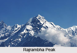
 The Rajrambha peak is situated in the Uttarakhand state of India. It is a part of the Himalayan mountain ranges, which lie in the Kumaon region. Every year its mesmerising beauty attracts adventurers from various corners of the world.
Location of Rajrambha Peak
Rajrambha Peak is located in the Pithoragarh district of Uttarakhand which is known as "Land of the Gods". This peak is situated in the south of the Kalabaland Glacier which is in the eastern Kumaun in the Ralam Valley. The peak is positioned at an altitude of 6,537 metres above mean sea level.
Meaning of Rajrambha
The literal meaning of the term Rajrambha is `celestial nymph` or Apsara in Hindi.
Attractions of Rajrambha Peak
The natural soothing view of the peak can be enjoyed from chaukori which is a tiny hill station in the Pithoragarh district. It can also be viewed from Khulia Top (Dhura), Munsyari and Gochar a hill town located in Karnaprayag tehsil within Chamoli district of Uttarakhand.
The other peaks located in the vicinity which form the north south massif are Suitilla at an average elevation of 6,373 metres, Chaudhara at a height of 6,510 metres and Ngalaphu at a height of 6,410 metres above mean sea level.
The Rajrambha peak forms a boundary between Lasser Yankti and Ralam Valley.
Accessibility of Rajrambha Peak
It is easily accessible from Uttari Balati glacier passing the Balati plateau. Dhakar situated near Tawaghat in Pithoragarh district is the base camp from where one can climb the Rajrambha peak.
This article is a stub. You can enrich by adding more information to it. Send your Write Up to content@indianetzone.com


