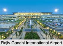
 Rajiv Gandhi International Airport is located in Shamshabad, south of Hyderabad. It is named after Rajiv Gandhi, former Prime Minister of India. It is also known as Hyderabad International Airport. It replaced the former international airport at Begumpet and commercial flight operations began on 23rd March 2008. It is the sixth busiest airport by passenger traffic in India.
It is owned and operated by GMR Hyderabad International Airport Ltd which is a public–private venture. It is composed of public entities Airports Authority of India and the Government of Telangana, as well as a private association between GMR Group and Malaysia Airports Holdings Berhad.
History of Rajiv Gandhi International Airport
When the state suggested the construction of a new airport for the Air Force, the Ministry of Defence suggested the state consider sites south of Begumpet Airport. The state had fined down to three possible locations for the new airport in October 1998 namely Bongloor, Nadergul and Shamshabad.
On 16th March 2005, the construction began when Sonia Gandhi laid the foundation stone. The international terminal was named after Rajiv Gandhi while the domestic terminal was named after Telugu Desam Party founder Nandamuri Taraka Rama Rao. The airport was inaugurated on 14th March 2008. On 16th March 2008, the airport was originally scheduled to open to commercial operations. The Lufthansa Flight 752 from Frankfurt was scheduled to be the first flight to land at the airport, two SpiceJet flights landed earlier also. SpiceJet launched its regional hub here in September 2011.
Structure of Rajiv Gandhi International Airport
Rajiv Gandhi International Airport has two runways. It has a single passenger terminal and the western side of the terminal handles international flights while the eastern side is for domestic operations. There are 46 immigration counters and 96 check-in desks with 19 kiosks for self check-in. There are a total of nine gates. The cargo terminal is located west of the passenger terminal. The airport is built on an area of 5,500 acres of land. It was designed by the United Kingdom based engineering design firm Arup, which designed Dubai Terminal 3 and Beijing Terminal 3.
Airlines of Rajiv Gandhi International Airport
Some of the major Airlines of Rajiv Gandhi International Airport are Air Arabia, Air India, AirAsia, AirAsia India, British Airways, Emirates, GoAir, IndiGo, Jet Airways, Qatar Airways, SpiceJet, Vistara, Thai Airways etc.
Visiting Information of Rajiv Gandhi International Airport
Rajiv Gandhi International Airport is connected to the city of Hyderabad by National Highway 44, National Highway 765 and the Outer Ring Road. The closest Indian Railways station is Umdanagar.


