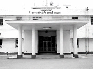
Raja Sansi International Airport is located 11 km north-west from the city of Amritsar, India. It is also known as Amritsar International Airport. The airport is situated on Amritsar-Ajnala Road near the Raja Sansi village. The airport is named after Maharaja Ranjit Singh`s family name - Sansi. The airport serves the city of Amritsar, as well as the greater Punjab area, including the city of Jalandhar. It is a government designated international airport. The Raja Sansi International Airport presently serves about 150 commercial flights a week, both international and domestic.
Air India AI (Delhi); Air Deccan (Delhi); Air India IC (Delhi) and Jet Airways (Chennai, Delhi) are the domestic airlines landing by the Raja Sansi International Airport. Air India AI (Birmingham, London-Heathrow, New York-JFK, Toronto-Pearson); Air India Express (Dubai); Air Slovakia (Bratislava); Girjet (Verona, Barcelona); Air India IC (Sharjah); Jet Airways (London-Heathrow); Singapore Airlines (Singapore); Transaero (Moscow-Domodedovo); Turkmenistan Airlines (Ashgabat); Uzbekistan Airways (Tashkent) are the international airlines flying to and from the airport. Many other international airlines will venture in future in the Raja Sansi International Airport.
 The Raja Sansi International Airport comfortably linked to the roads and main highways of Punjab. The most popular way of reaching the airport is automobiles as the public transport infrastructure (with the exception of taxis) is quite weak. However this shall change with the Punjab State Government`s launching of plans to establish regular bus services between the airport and other cities of Punjab. Air India has also brought out plans to provide regular bus services. The state government has also disclosed projects to build a monorail line to connect the airport with the Golden Temple and Amritsar Railway Station.
Like other international airports, the Raja Sansi International Airport is also planning to upgrade its standard. Amritsar has always remained the cultural and tourist capital of Punjab. In order to live up to the criterion, a new arrival terminal was inaugurated in September 2005, and since March 2006 a departure terminal is also operational. The new terminal has been designed blending the modern and Indian designs. It was constructed of glass and steel applying Indian arches and colours.
In the second phase of development, the Raja Sansi International Airport plans to incorporate--
"A brand new cargo that will handle the facilities to fulfill the demands of exporters in Punjab, Haryana and Himachal Pradesh, who have no alternative apart from Delhi which is far too far away.
"For the Permanent Perishable Cargo Centre the proposed site will be located close to the air cargo complex, which has a capacity of 200 tonnes per day.
"Passenger terminal building size to be doubled to 41,000 square m
"For the convenience of passengers, four new air/jet bridges to be installed (Amritsar currently has 0 air / jet bridges).
"Four more parking bays to be added by 2008 (ATQ currently has 5).
"The runway to be extended by 369 metres to a total length of 3,658 metres.
"A new spacious car park for passengers and visitors will come about.
Book Stall; Snack Bar; International Money Change; STD / ISD/ PCO; Juice Bar; Free Baggage Trolleys; Free Wheel Chair; Free Medical Facility are the available facilities for the passengers of the Raja Sansi International Airport. Airlines like Jet Airways, Air India have already experienced heavy load in traffic compared to the traffic of Delhi-London and Mumbai-London.


