 Puttenahalli Lake is a small restored freshwater lake in the southern part of Bengaluru city, in the state of Karnataka. It is not to be confused with the Yelahanka Puttenahalli Lake (also referred to as Puttenahalli Lake) which is situated near suburb Yelahanka in the northern part of the city.
Location and Area of Puttenahalli Lake
Puttenahalli Lake is located in J. P. Nagar 7th Phase area in South Bangalore. It lies between two residential apartment enclaves "Brigade Millennium" and "L&T South City", in the Bruhat Bengaluru Mahanagar Palike (BBMP) ward 187.
Its recorded area is 13 acres 25 guntas, with a total perimeter of 1.1 kilometres and 920 metres walking track perimeter. The lake is the smallest of the 3 lakes situated in J. P. Nagar 7th phase, the other two being the Jagranahalli Lake or Sarakki Lake which is the largest and the Churchaghatta Lake.
Deterioration and subsequent Restoration of Puttenahalli Lake
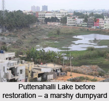
Puttenahalli Lake was one of the pristine lakes of Bengaluru for centuries and also a source of drinking water. As a result of continued development and infrastructural activity, encroachment by slum dwellers, unethical and insensitive dumping of garbage and debris, inflow of sewage, the lake had almost dried up and lost its life. Pollution and neglect had brought it on the brink of extinction.
Seeing the pathetic and dying condition of the lake and the unhygienic scenario, a group of citizens decided upon reviving and rejuvenating the lake. The initiative was taken by Usha Rajagopalan who set up Puttenahalli Neighbourhood Lake Improvement Trust (PNLIT) which resorted to revitalizing the lake, with the main strategy of engaging the local and neighbourhood residents and utilisation of donation funds from them into the lake"s conservation. Their proactive strategies also encompassed ensuring diversion of rainwater from all possible sources into the lake and no inflow of sewage and pollutants. Their objective was to transform the lake into a secure and preserved avian habitat, so that it creates the impetus amongst the citizens to restore other deteriorating lakes in the city.
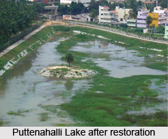
The willingness and action of the Trust successfully led to a turnaround transformation and restoration of Puttenahalli Lake. About 62 species of birds and 15 species of butterfly attracted by the various shrubs planted, inhabited the lake and its surrounding zones. A track around the lake is meant for joggers and walkers and has dustbins placed at every few metres. More than 300 trees have been planted and a small canopy has been built for the people to gather and have a relaxing time. The lake became like a sanctuary in the middle of an urbanised culture and a bird watcher"s delight in the heart of human habitation.
The PNLIT continued to work with similar bodies and governing authorities for lake"s maintenance with rainwater harvesting strategy, getting a diversion channel built through the Brigade Millennium Avenue Road, ensuring inflow of monsoon run-off. They also got sewage water entering the lake diverted into an underground drain. It also conducted many social events to promote welfare of the lake and sustenance of its biodiversity. The continued efforts of the PNLIT made them the first citizens" group in the city to officially maintain a lake, when they signed a Memorandum of Understanding (MoU) with the BBMP. The governing body"s initiatives have also been recognised, the most significant achievement of them being the engagement of local residents and convincing the neighbourhood societies to let off only treated water into the lake.
Floral Attractions at Puttenahalli Lake
The multifarious flora seen at the Puttenahalli Lake includes African Tulip, Bottlebrush, Curry Tree, Custard Apple, Indian Almond, Indian Mahogany, Mango, Neem, White Teak, Bamboos, Bougainvillea and Rosewood.
Avifaunal Attractions at Puttenahalli Lake
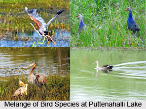
The Puttenahalli Lake is home to a resplendent range of avifaunal species. Bird sightings of more than 80 species, both migratory and non-migratory, have been tracked at Puttakere hotspot on eBird. These include Gray and Purple Herons, Little and Cattle Egrets, Indian Pond Heron, Spot-billed Duck, Brahminy Kite, Rock Pigeon, White-cheeked Barbet, Rose-ringed Parakeet, Red-whiskered Bulbul, White-throated Kingfisher and several others. It thus is a paradisiacal venue for bird watching.
Ongoing Restoration Works for Puttenahalli Lake
The primary sources of the Puttenahalli Lake are the rainwater and surface water diverted to it through the channels. The governing body PNLIT and its efforts for the lake"s rejuvenation were successful and it continues to work regularly with the BBMP for further improvements to the lake and its area. Taking care of the lake for more than 4 years, it receives the necessary infrastructural support from the BBMP while the financial support comes from the donations of neighbourhood citizens. The Karnataka State Pollution Control Board (KSPCB) approved a proposal to get treated water from the "L&T South City" residential complex having its own sewage treatment plant, let into and fill the lake. The lake with this tactic will brim with around 400 kilolitres of clean water every day. The bird population along with the water table would increase with this implementation. Some part of the lake area is encroached by hutments and the Upa Lokayukta is working towards their rehabilitation.
The Puttenahalli Lake is thus on its way to complete restoration with sustained preservation.


