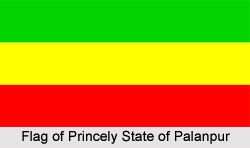
 The Princely State of Palanpur was one of the prominent princely states of India that were administered by native rulers or Indian princes under the indirect control of the British Government of India. The capital of the state was at the city of Palanpur. The Lohani clan of Afghans was the ruling family of the state. The princely state of Palanpur covered a total area of 1766 sq km and comprised of a total population of 222,627 in the year 1901 and a population of 315,855 in 1941. The state was a part of the Rajputana Agency in Western Rajputana States Agency. The name of the state comes from the Palansi Chauhan Rajputs who inhabited it in early times. Until the year 1933, Palanpur state belonged to the Sabar Kantha Agency situated in Gujarat.
Palanpur was located in the southern Rajputana. The territory was bounded by Jodhpur in the north; by Sirohi in the northeast, by Danta in the east, by Sudasna in the southeast, by Kadi district of Baroda in the south, by Kankrej Thana in the southwest, by Deodar in the west and by Tharad in the northwest. At present, Palanpur is a municipality of the district of Banaskantha in the Gujarat state. Palanpur is the largest city and the administrative headquarters of the district.
The history of the ruling family of the princely state is rather vague. The Lohanis seeked the protection and support of the British East India Company and in the year entered the subsidiary alliance system. It is also considered that the Jhaloris were the ruling family of Palanpur state who originally belonged to Yusufzai Lohani Pathan clan. The dynasty was established as the rulers of Jhalor, in Jodhpur around 1370, under the guidance of Malik Khurram Khan.
The Princely State of Palanpur has honoured as one of the salute states of India with a salute of 13 guns. Palanpur was in the 8th rank in order of precedence amongst the Western India states, directly above Radhanpur. The official title of the native ruler of the state was Nawab. The Nawab of Palanpur had full ruling powers and was in charge of the administration of the princely state. The region was segregated into 6 mahals, Panthawada, Dhanera, Deesa, Gadh, Vadagam and Palanpur. It incorporated 516 villages, out of which 4 villages were in Gadhwada thana and comprised of a separate tahsil. The courts of the princely state exercised full civil and criminal jurisdiction. The state of Palanpur paid an annual tribute to the Gaekwad, the Maratha ruler of Baroda. Since the year 1896, the British currency became the only legal tender. The Rajputana Malwa railway traversed the state with its main line constituted the British cantonment of Deesa.
The major agricultural products of the princely state of Palanpur were sugarcane, rice and wheat. The region was drained by the Sabarmati River. The territory was adorned with hilly landscape, being at the edge of the Aravalli Mountain Ranges.
After India achieved independence in the year 1947, the princely state was acceded to the newly formed Union of India, also known as the Dominion of India, by the last ruler of the state in the year 1949.


