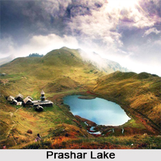
 Amidst the Dhauladhar ranges of Kullu valley, is a blue lake called Prashar Lake, set in nature"s pristine beauty in a saucer-shaped valley.
Location and Altitude of Prashar Lake
Prashar Lake is located 50 kilometres north-east of the Mandi district in the state of Himachal Pradesh. It lies at an elevation of 2,730 metres above mean sea level in the lap of mountains. It is nestled in the Dhauladhar ranges of the Kullu Valley Himalayan region.
Attractions of Prashar Lake and its surroundings
The Prashar Lake is nature"s epitome of tranquillity and spirituality. It is named after the sage Parasara, father of Veda Vyasa, who is believed to have meditated here. The lake is thus considered sacred.
The lake and its surroundings make an absolute picturesque landscape. Surrounded by lush hills, mountains, snow-capped peaks and looking down on the fast flowing River Beas, the deep blue lake holds a little island floating over it, continuously revolving and altering its position at regular intervals, which is quite interestingly unique. The primary inflows to the natural sweet water lake are rainwater and glacier melted water. The depth of the lake is unknown and unascertained by divers.
Alongside this lake is a three-storied "pagoda" (tiered tower with multiple eaves) like temple dedicated to sage Parasara. It was built in the 14th century by Raja Ban Sen of Mandi, having a roof of slate tiles and structured with wood carvings. The lake offers fishing and boating activities and the area being less populated, serene, unpolluted and untouched by modern amenities, along with panoramic views of lush and snow-capped mountains, overall becomes a paradisiacal and exciting excursion site. There are cows, horses and lambs grazing around and small mud huts in nearby villages, where various colourful festivals and fairs are celebrated.
Myths associated with Prashar Lake
It is believed that Prashar Lake was formed by the Pandavas, when on their way after Mahabharata with their mentor deity Kamrunag, who loved the place"s isolation so much decided to live forever there. On his request, Bhima, one of the Pandavas, formed this lake by pushing his elbow and forearm on the mountain"s peak, and this is the reason as per the locals, behind the oval-shaped lake with unclear depth. Faith brings many people to this lake, where they throw money, silver coins and gold into the water. With increased faith and increased number of visitors, few accommodation hotels have come up near it.
 Approach to Prashar Lake and Accommodations nearby
Prashar Lake can be approached along an ideal 8 kilometres trekking trail from the Bagi village, through dense forests, several rivulets and enchanting views of Dhauladhar, Pir Panjal and Kinnaur ranges, taking almost 5 hours to be completed.
By Road: The Mandi district has a good road connectivity with major cities like Delhi and Chandigarh, from where buses can be availed to reach there, and then a motorable 26 kilometres road via Katula village leads to the Bagi village. This road gets covered with snow during winters, and thus, gets difficult to be travelled along. The road from Bagi village to the lake is motorable except in the winters, when heavy snowfall blocks the route and trek from the village becomes the only accessible way to the lake.
By Rail: The nearest railway station to the Bagi village is the Joginder Nagar railway station at 34 kilometres distance.
By Air: The nearest airport is at Bhuntar in the Kullu district, 28 kilometres from Bagi.
A PWD guest house and a Forest Department guest house are the accommodations available for stay purposes to the visitors. They are at a walking distance of 300 to 400 metres from the lake, providing resplendent views of the lake and scenery around, along with the basic facilities and cooking.
Best time to visit Prashar Lake
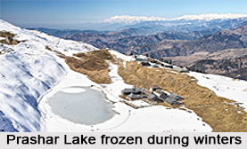
The Prashar Lake and its nature"s exquisiteness and tranquillity can be explored throughout the year except during the rainy season, when landslides occur in hilly areas. During winters, the lake remains frozen and the surrounding hills and valleys are covered with snow, providing an adventurous yet delightful trekking experience to the lake.


