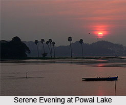
 Powai Lake, situated near Mumbai city of Maharashtra, is an artificial lake and a mesmerizing tourist destination. It lies in the Powai valley which also shelters a Powai village having a cluster of huts. The lake has been named after Framaji Kavasji Powai Estate. The suburb of the city also shares its name with the lake and is called as Powai. During the time of its construction, the lake spanned over an area of around 2.1 square kilometres with a depth varying from about 3 to 12 metres. Several stages of water quality degradation have been encountered by Powai Lake. Previously the water of the lake was used for supplying drinking water to Mumbai but it was later declared as unfit for drinking. Premier institutions like National Institute of Industrial Engineering and Indian Institute of Technology Bombay are located near the lake.
History of Powai Lake
Powai Lake was built in the year 1891 by the British with the aim of supplying drinking water to the city of Mumbai. However later, owing to the complaints of poor water quality, it was abandoned. Following this, the lake was used for the purpose of fish culture and angling. Another attempt was also made to restore its water quality and supplying water to the suburbs but the efforts remained unsuccessful. However restoration works were carried out in the lake extensively for reducing its pollution and silt deposition and gradually it emerged as a site for fishing and recreation.
Hydrology of Powai Lake
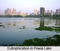
Powai Lake receives an average rainfall of about 2,540 centimetres which makes it overflow each year for about sixty days. The overflow goes into the Mithi River. Since its construction, around 4500 lakh cubic metres of silt has deposited in the lake. Powai waters were once also used for irrigation and it drained a catchment of 6.61 square kilometres. Owing to eutrophication of the lake water with untreated sewage and garbage from nearby slum and residential colonies, its water has become unfit for drinking. Presently the lake serves the purposes of fishing, cattle washing, gardening and recreation. The lake water has dissolved oxygen (DO) level of 0.71 mg/litre at the bottom and 4.11 mg/litre at the surface. The average pH value of the water is 7.2.
Flora and Fauna of Powai Lake
Powai Lake is surrounded by a carpet of Balsam bushes which flaunt their pink-purple hues during full bloom. The lake sides also shelters a number of faunal species. Several crocodiles can be spotted on the lake shores. Avian species found near the lake enlist Ashy Prinias, Pheasant-tailed Jacanas, Purple-rumped Sunbirds, Purple Swamphens, Spotted Dove, Spot-billed Duck, Small Blue Kingfisher, White-throated Kingfisher, White-browed Bulbuls, Great Egrets, Peregrine Falcon, Woolly-necked Stork and many more. Many migratory birds are also seen nearby. Beetles, Bumble Bees, Honey Bees and Butterflies are also common sights.
Rejuvenation of Powai Lake
The condition of Powai Lake was reviewed in 1995 by the National Lake Conservation Plan (NLCP) of the Ministry of Environment and Forests, Government of India, following which it was included in the list of ten major lakes in the country for revival and improvements. In April 2002 the restoration/ revival programme was launched under the funding of the NLCP. The programme was implemented by Bombay Municipal Corporation (BMC) presently called Brihanmumbai Municipal Corporation (BMC), the Government of Maharashtra. Owing to its efforts, the condition of the lake underwent major changes from hypertrophic condition to mesotrophic condition. New techniques of bioremediation and aeration were applied. This made Powai Lake useful for fishing and recreational purposes.


