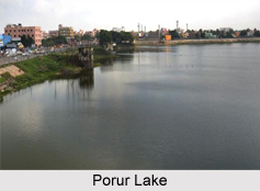
 Porur Lake is located in the Indian state of Tamil Nadu. More specifically, this lake is located on the fringes of the suburb of Porur in south-west Chennai. Porur is a town Panchayat located in Tiruvallur district in the Poonamallee taluk. It holds an important place on the Mount Poonamallee Road. Among the locals of Chennai, this lake is famous as Retteri or Porur aeri. The Chennai bypass provides a beautiful view of the lake.
Functions of Porur Lake
Porur Lake functions as a chief source of water for the people residing in Chennai. It also acts as a drainage area that is connected with the Chembarambakkam Lake.
Geography of Porur Lake
Globally, this lake can be pinpointed at coordinates, 13.034223 degrees north and 80.15065 degrees east. It occupies a water spread area of 250 acres with a capacity of 46 million cubic feet. Throughout the day, four filters are under operation for pumping water to the K.K. Nagar double tank distribution spot.
Ecological Crisis Faced by Porur Lake
Many uncontrolled and illegal activities also termed as encroachment are responsible for disturbing the ecology of any setting or area. Porur Lake also acquired the ill fate of many other lakes in India in terms of degradation of water quality. This is evident from the observations of the residents of Porur. According to these residents, Porur Lake has turned into a dumping ground for garbage and the release of sewage. They have even emphasized on the fact that when this lake"s bund would be breached, flooding of several localities around the lake would be its consequence. This troublesome event would take place every year during the monsoon season.
Restoration of Porur Lake
Since 1995, the government has prohibited activities like swimming, bathing and washing clothes in Porur Lake. In the year 2012, another initiative was taken by the Water Resources Department (WRD), not only to restore the lake, but also to meet the city"s growing demands for drinking water. This project was aimed at increasing the capacity of the tank to 70 mcft. The Nemam and Ayanambakkam lakes were also part of the same project, selected for the creation of additional water storage for the city. The budget of this restoration project was fixed at Rs. 20-crore. The execution of the project would involve the lake to be de-silted and its capacity increased from 46 million cubic feet of water (mcft) to 70 mcft. This would help in supplying two days of water to Chennai. Efforts were also taken to convert a portion of the Thanthikal channel into a concrete facility. This channel functions to supply the excess water from the Chembarambakkam reservoir to Porur Lake and passes through rapidly-developing areas such as Bharanipudhur and Iyyapanthangal. This initiative was focused on the prevention of illegal release of sewage into the channel from these areas, thereby saving the quality of Porur Lake from being compromised. The restoration project was also focused at constructing a bund at a radius of about 5km and fencing the area around developing stretches. According to Chennai Metrowater officials, this project was also complimented by relevant infrastructure required to transport two million liters of water a day from Porur Lake to various parts of the city.
It is known that despite the relevant restoration efforts, encroachment still continued to be a threat to Porur Lake. This encroachment involved setting up of huts in Iyyapanthangal. According to the local residents, if the huts on the lake bed were not removed, the perennial problem of the misuse of the water body and the breaching of the lake"s bund during rains would continue. Fortunately, this problem came to the notice of the Officials of the Water Resources Department, who had given their word to remove all the encroachments in a week"s time.
Tourism of Porur Lake
On a visit to Porur Lake, one also has an opportunity to explore the nearby attractions of this lake. Some of these nearby attractions are Gopala Krishna Theatre, Mouleeswarar Temple, Kamatchi Amman Temple, Sanjeevi Theatre, Siva Temple, Ars Garden, Shiva Parvathi Pushpa Garden, Thangam Cinema, E.C.I Church, Sri Kailasanathar Temple, Thangam Cinema and Krishu Jyothi Church.
Visiting Information
Porur Lake has good transport availability. Since Porur Lake is located in Chennai, its transportation is of relevance to Porur Lake. Chennai is 5 km away from Porur Lake. The nearest airport to Porur Lake is Chennai International Airport. Nearest railway station to this lake is Mambalam Railway Station. This railway station is about 8 km away from Porur Lake.
Related Articles:
Lakes of India
Chembarambakkam Lake
Veeranam Lake


