Home > Indian History > Geography of India > Porbandar Airport
Porbandar Airport
Porbandar Airport is a public airport in Porbandar, Gujarat.

Share this Article:

Porbandar Airport, GujaratPorbandar Airport is a public airport which is situated in Porbandar in the state of Gujarat. Porbandar is one of the popular cities of India and well connected through air route to all major cities in India. Apart from civilian operations it also has a military presence. A new terminal building was opened in April 2008. Porbandar Airport Authority is working for the development of the airport. The authority also manages various services such as cargo and custom for security purposes.

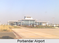
Structure of Porbandar Airport
The airfield is spread over 278.32 acres, has a 4500 feet long runway and an apron that can accommodate 2 ATR 72 aircraft. The new 4000 sq m Terminal Building at Porbandar Airport has been built in April 2008. The building has 6 `Check-in` Counters and 2 `Conveyor Belts` in the Arrival hall. This airport is capable to handle 100 arriving and 100 departing passengers at one time. New domestic terminal is made in this airport which is equipped with latest and modern facilities. Passengers can get flights to various locations from Porbandar Airport.

Facilities at Porbandar Airport
This airport has now come up with new domestic terminal where one can get free baggage services. Wheel chairs are also available in the Arrival hall for disable person to reach the terminal easily.

Various shops and stores are available on the terminal which provides the travellers with necessary items. Passengers can satisfy their hunger by taking refreshment from the food and beverages stores. Stationery items such as books, magazine, newspapers are also easily available on the shops which help the visitors to spend their time.

Transport Facilities at Porbandar Airport
Porbandar Airport is about 5 km far from the city having many public transports which facilitates the passengers to reach the bus stand easily. Roads are well linked with other cities and states which make the journey easier and comfortable. State Transport Buses are available for Dwarka, Junagadh, Ahmedabad, Rajkot, Jamnagar and many more. One has to take taxi, bus or any other public transport to reach the Porbandar Railway Station. Frequent and regular trains are available for different destinations.


Share this Article:

Related Articles

More Articles in Geography of India


Geography of Uttar Pradesh
The fourth largest State in India UP is located in the Northern part of India whose area is 2,36,286 sq Kms.
Geography of Maharashtra
Covering an area of 308,000 sq. km, Maharashtra, the third largest state in India.
Geography of Kerala
Geography of Kerala includes plains, hills, valleys and coasts. With the Arabian Sea in the west, the Western Ghats in the east and networked by several rivers, Kerala enjoys diverse geographical features.
Geography of West Bengal
The geography of West Bengal is unique with high peaks of the Himalayan range in the north, the Bay of Bengal in the south and the remaining region is covered with both plains and plateaus.
Geography of Jharkhand
Geography of Jharkhand is comprised of the rich mineral resources and the highly agricultural prospect in this state.
Geography of Sikkim
Geography of Sikkim is characterised by a vast array of magnificent hillock that extends from one corner of the state to the other.
Geography of Meghalaya
The suitable climate, highland plateaus, rivers and the flora and fauna together forms the geography of Meghalaya.
Geography of Mizoram
Mizoram is surrounded by hills, valleys, rivers, waterfalls and lakes. The hills range from 1000 meters to 2000 meters. Rivers, lakes and waterfalls also play major role in forming the land of Mizoram.
Geography of Jammu & Kashmir
Jammu and Kashmir is encompassed by valleys. Some of the dominant valleys of the state are Kashmir Valley, Tawi Valley, Chenab Valley, Poonch Valley, Sind Valley and Lidder Valley etc. Jhelum River is the only major Himalayan River which flows through the Kashmir valley. Indus, Tawi, Ravi and Chenab Rivers are the major ones flowing through the region.
Geography of Daman and Diu
Daman and Diu is situated on the west coast of India and are the smallest union territories of India.
Geography of Goa
Geography of Goa occupies a prime location along the Konkan coastal belt on the western coast of India. The state is bordered by Maharashtra in the north and Karnataka in the south. The Western Ghats in the east contribute to the flora and fauna of Goa.
Geography of Arunachal Pradesh
Geography of Arunachal Pradesh reveals that it is a hilly tract nestled in the foot of Himalayas.
Geography of Kutch
Geography of Kutch District is covering an area of 45,612 km. Kutch District is the largest district in the state of Gujarat.
Geography of Ladakh
Geography of Ladakh mainly comprises the huge Karakoram Range with long stretch of cold desert which mark the region separately from the rest of the states of Indian subcontinent. Surrounded with the mountain ranges from all corners this small region separates Indian subcontinent from rest of the Asian continent.
Geography of Rajasthan
Geography of Rajasthan defines the dry topography with arid climate of the western mountain region.
Geography of Tamil Nadu
The Indian state of Tamil Nadu is located in the Northern hemisphere in the hot zone.