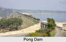
 An artificial dam on the Beas River, the Pong Dam is also known as the Beas Dam and is located in the state of Himachal Pradesh, just upstream of the town of Talwara. The construction of the dam began in the year 1961 and was completed in 1974 and at that time was known as the tallest of its type in the country.
The raised water level thus invariably created an artificial lake called the Maharana Pratap Sagar, after the great ruler of Mewar. This lake soon became a renowned bird sanctuary for birds of numerous species including Bar-headed Goose and the Red-necked Grebe.
History of Pong Dam
The Pong Dam was conceptualized in the year 1926, while in 1927, the Punjab Government passed orders for conducting surveys of Indus River and its tributaries. However, the presence of flood waters dampened the motivation to build this dam. Hydrological and geological studies were performed around the region of Pong in 1955 and a design for its embankment was also proposed. More studies were conducted in the year 1959 and a gravity section was recommended with the embankment dam. The construction of the dam started immediately after the final design was issued in 1961. This was the second phase of the Beas Project, the first phase of the project being the Pandoh Dam upstream at about 140 km. In 1974, the construction of the Pong Dam was completed and between the years 1978 and 1983, a power station was commissioned. The expansive reservoir of this dam had displaced nearly 1, 50,000 people, due to a faulty relocation plan.
Architecture of Pong Dam
The Pong Dam is an earth-fill embankment dam with a gravel shell at a height of about 133 m and extends at a length of 1,951 m. The dam is 13.72 m wide at its crest, which sits at an elevation of about 435.86 m above sea level. The base of the Pong Dam is about 610 m wide and has a total volume of 35,500,000 metre cube. The dam"s spillway is located on its southern bank and is a chute type controlled by 6 radial-gates with a maximum discharge capacity of 12,375 metre cube per square. The dam creates the reservoir of the Maharana Pratap Sagar which has a gross capacity of 8,570,000,000 metre cube of which 7,290,000,000 metre cube is active or live capacity. The surface area of the reservoir measures about 260 square km. The power house is present at the base of Pong Dam. Water is supplied with the aid of 3 penstocks which are connected to a Francis turbine generator which has a voltage of 60 MW.
The construction of the large reservoir created by the Pong Dam resulted in a major displacement of people from the state of Himachal Pradesh. A total of 90,702 people were displaced and 339 villages affected.


