 Pilibhit District is the north-eastern most district of Rohilkhand division which is situated in the sub Himalayan belt on the boundary of Nepal. Pilibhit city is the administrative headquarters of this district of Uttar Pradesh. According to the census of 2001 the total population of Pilibhit District is 1645183, out of which rural population is1350959 and urban population is 294224. It is said that this region had always been occupied by the Banjaras of the Periya clan. It is supposed that Pilibhit is the corruption of Periya Bhit or the village mound of the Periyas.
Location of Pilibhit District
It lies between the parallels of 28 degree 6 minutes and 28 degree 53 minutes north latitude and 79 degree 57 minutes and 80 degree 27 minutes east longitude. On the north are the districts of Udhamsingh Nagar and the territory of Nepal, on the south lies Shahjahanpur district, on the east the district is flanked for a short distance by district Kheri and for the remaining distance by Shahjahanpur district and on the west it is bounded by Bareilly District.
History of Pilibhit District
In 1801 when Rohilkhand was ceded to the British government Pilibhit was a Pargana of the Bareilly District, which lost it in 1833, as the arrangement was temporary and the tract being again united with Bareilly in 1841. In 1871, Pilibhit subdivision was formed comprising Jahanabad, Pilibhit and Puranpur which was eventually converted into a separate district in the year 1879. With the arrival of British rulers in the country, the Parganas of Pilibhit, Jahanabad and Bisalpur were formed into separate Tehsils. Puranpur was united for this purpose with Khutar. A redistribution of the area was made in 1824, when Bisalpur Tehsil contained the Parganas of Bisalpur and Maurari, which afterwards became a single area; Jahanabad was joined with Richha to form tehsil Pareva and Pilibhit with Bilheri, the headquarters being at Pilibhit. In 1851 Bilheri was taken under direct management and in 1863 Richha was attached to the new Baheri Tehsil, Jahanabad Pargana being attached to Pilibhit which also received Puranpur on its transfer in 1865.
 The latter, in 1871, became a sub-tehsil. The promotion of Puranpur into a full Tehsil took place in 1879, while Bisalpur throughout remained a separate sub-division. Thus, the area is now divided into three Tehsils and four Parganas. Puranpur and Bisalpur formed individual Tehsils and Parganas whereas the Tehsil of Pilibhit included the Parganas of Pilibhit and Jahanabad.
Geography of Pilibhit District
In its general appearance Pilibhit District presents diverse features and topographically it may be divided into several distinct tracts. In the north and north-west the tract is a continuation of the Terai region. The southern portion of the Bisalpur Tehsil is similar in most respect to the adjacent tract of Bareilly and Shahjahanpur. The eastern and smaller section approximates rather to undeveloped forest areas of Khiri, though with the spread of cultivation the dissimilarity between Puranpur and the rest of the district is gradually becoming less marked. This district is traversed by several rivers like Gomti River, Khanaut, Mala, Deoha, Khakra and more. Sharda canal is the main canal of the district. Major part of Pilibhit District is covered by dense forests.
Economy of Pilibhit District
Economy of Pilibhit District is mainly dependent on agriculture. The main crop cultivated in this area is sugarcane. So, there are four sugar factories at Majhola, Puranpur, Bisalpur and Pilibhit. Three factories are in co-operative sector. Some small scale industries of the district include Rice mills, engineering units, brick kilns, candles and mainly flute manufacturing.
Tourism in Pilibhit District
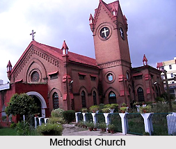
Tourism in Pilibhit District includes visits to several places of interest with historical and religious significance. Some of the noteworthy tourist attractions are Jama Masjid, Chhathavi Padshahi Gurudwara, Ardhanarishwer Temple, Raja Venu ka Tila, Jaisantri Devi Temple, Gauri Shankar Temple, Raja ji Temple, Methodist Church, Devha-Ghaghra Sangum and Tiger Reserve.
Pilibhit Tiger Reserve came into existence in the year 2008.


