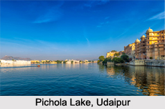
 Pichola Lake is an artificial fresh water lake in and around the beautiful city of Udaipur, Rajasthan. Named after the nearby Picholi village, it is one of the most picturesque attractions in the city.
Location and History of Pichola Lake
Located at the heart of Udaipur city, Pichola Lake, like several contiguous lakes in and around Udaipur, was created by building dams, for the primary purpose of irrigation and drinking water supply to the city and its neighbours.
Pichola Lake was built in 1362 AD, originally by a Banjara, also known as gypsy tribesman, who used to visit the place transporting grains. Later, Maharana Udai Singh II, impressed by the lake"s scenic beauty and the lush hills backdrop, established the city of Udaipur on its banks. He expanded the lake by constructing a stone masonry dam on its shore. Its surroundings and several islands within were developed over centuries, and today there are palaces, marble temples, family mansions, bathing ghats or "chabutaras", one of which is the famous Lake Palace, a heritage luxury hotel today where a popular James Bond film of the 1980s was shot.
In the vicinity of Udaipur are many lakes connecting with the Pichola Lake, like the Swaroop Sagar Lake connected with an arched bridge, which in turn connects with the crystalline Fateh Sagar Lake.
Attractions in and around Pichola Lake
While cruising the Pichola Lake, one gets a wholesome feeling of the beautiful blend of culture and romanticism that the city of Udaipur exudes. These attractions in and around the lake include its 4 islands: Jag Niwas, where the magnificent Lake Palace or Pichola Palace is built, Jag Mandir with a palace of the same name, Mohan Mandir, from where the king would witness the annual celebration of Gangaur festival and the small Arsi Vilas island, which is a sanctuary to varied bird species. Also, the City Palace of Udaipur and gardens on its southern end is another go to place, along the eastern banks of the lake. Within the palace, there are many ghats from where the boat rides to stop at various attractive spots are available. The boat trip on the lake at sunset, is popular and a must experience. Among the "chabutras", the Natini Chabutra is a prominent one, built to commemorate the legend of the Natini"s Curse.
Hydrology of Pichola Lake
Pichola Lake receives its waters from the Sisarma stream, a tributary of Kotra River, draining a catchment from the Aravalli ranges and contributing to the lake"s flow. During severe drought conditions, the catchment degrades and the lake remains dry. The water of the lake has been assessed as polluted with a high sodium and bicarbonate content, and the lake faces alarming threats owing to factors such as dumping of sewage and wastes, large scale development activities like mining in the area, encroachments and alike. The deteriorated water quality has led to the death of majority fish species. As such, the government along with NGOs have implemented measures to restore the water quality, having eradicated hyacinth, while sewerage treatment plan and catchment conservation through watershed project are under implementation.
Accommodations near Pichola Lake
There are a number of private hotels, havelis, resorts, palaces and guest houses for the visitors to stay, in and around Pichola Lake, as the place and the city are major tourist destinations. The accommodations also act as major venues for Indian wedding ceremonies. Lake Pichola Hotel is one of these and of course the renowned heritage luxury Taj Lake Palace too, with 83 rooms and suites featuring white marble walls.
Visiting Information to Pichola Lake
Pichola Lake is conveniently accessible to visitors from all walks of life.
By Road: It is approachable from Udaipur city, by all conveyance means, and the city itself is well connected with other major Indian cities, being 6 hours from the state"s capital Jaipur and 3.5 hours from Ahmedabad. The Maharana Pratap bus stand in the city is 3 kilometres away from the lake.
By Rail: The nearest railway station is the Udaipur Railway Station itself, distanced 3 kilometres from the lake.
By Air: The Dabok Airport in Udaipur is the nearest that is 25 kilometres from the lake.
Best Season to visit Pichola Lake
The best time to visit Pichola Lake is between the months October and April, when the scorching summer prevalent in Rajasthan is taking a break.
Rudyard Kipling mentioned this lake in his Letters of Marque (1899), "If the Venetian owned the Pichola Lake, he might say with justice, "see it and die"". Pichola Lake is a priceless asset beautifully justifying the romantic and cultural richness of Udaipur to the tourists, with its sheer stunning beauty.


