 Indian physiography of the Western Regions implies the physical traits of the different portions of the country which lie in the western states of Rajasthan, Gujarat and Maharashtra. The diversity in Indian climates and regional geography has given birth to unique topographical features, climate, water resources and other physical divisions in Western India.
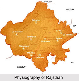
Physiography of Rajasthan
The geographical coordinates of Rajasthan are 23o3` to 30o12` north latitude and 69o30` to 78o17` east longitude. The total area of Rajasthan is 2, 42, 239 square kilometre. Prolonged periods of erosion and deposition have been responsible for the present physiography of this state. Aravalli Mountain range divides Rajasthan into two distinct portions.
| 1. Western Plains |
| a) Dry Sandy Plains or `Marusthali` |
| b) Semi-Dry Plains or `Rajasthan Bagar` |
| Luni Basin (Godwar Tract) |
| Plain of Interior Drainage (Shekhawati Tract) |
| Ghaggar Plain |
| 2. Aravalli Mountains or Hilly Tracts |
| a) Aravallis and Bhorat Plateau |
| b) North-Eastern Hilly Region |
| 3. Eastern Plains |
| Banas Basin |
| Chappan Plains |
| 4. South-Eastern Plateau or Hadoti Plateau |
| Deccan Lava Plateau |
| Vindhyan Scarland |
Climate of Rajasthan
Rajasthan`s climate can be classified into four basic categories and sub-categories like summer, monsoon, post-monsoons and winters. Summers are characterized by hot and dry climate, when temperatures shoot up to over 45 degree Celsius and `loo` winds start blowing throughout the state. However,
Mount Abu, the one and only hill station in Rajasthan remains comparatively cooler even during the simmering temperatures during this season. Sometimes, temperatures rise to above 75 degrees Fahrenheit to 105 degree Fahrenheit with an average rainfall of 11 mm to 30 mm. Summers dominate this region from April to June.
Monsoons are much more comfortable and the regional people experience moderate temperatures during this time. Humidity is quite high in monsoons in this state and this period of the year attracts tourists the most. The average temperature hovers around 70 degree Fahrenheit to 95 degree Fahrenheit. The months of July to September witness monsoons.
Tourists visit Rajasthan during the post-monsoon season, as temperatures generally are about 55 degree Fahrenheit to 85 degree Fahrenheit. The average quantity of rainfall Rajasthan receives during this time is 3 mm to 8 mm. This type of weather exists from October to December.
Winters are considered to be the most pleasant time to visit Rajasthan, particularly between December to March. Temperatures hover around 50 degree Fahrenheit to 80 degree Fahrenheit. January is said to be the coldest time of the entire year. At times, temperatures might drop to as drastic as 0 degree Celsius.
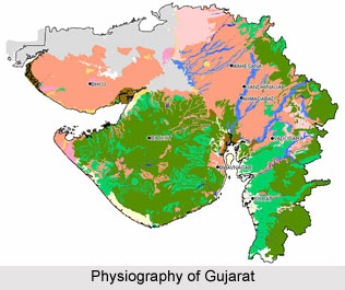
 Physiography of Gujarat
Gujarat`s geographical coordinates are
23°13` north latitude and 72°41` east longitude and its total area measures about 1, 96, 204 square kilometres. The land of Gujarat can be broadly classified into three divisions: the mainland of Gujarat, the peninsular region of
Gujarat and the
Kutch area of Gujarat.
| 1. Mainland of Gujarat |
| a) Plains formed by Indus River |
| b) Plains formed by Sabarmati River |
| c) Plains formed by Mahi River |
| d) Plains formed by Narmada River |
| e) Plains formed by Tapti River |
| f) Aravalli Mountains |
| g) Taranga Hills |
| h) Vindhya Mountain |
| i) Rajpipla Hills |
| j) Shivrajpur Hills |
| k) Rann Of Kutch |
| l) Sabarmati River |
| m) Mahi River |
| n) Narmada River |
| o) Tapi River |
| 2. Peninsular Gujarat |
| a) Shetrunjaya Mountain |
| b) Chamardi-Chogat Hills |
| c) Talaja Lor Mountains |
| d) Chotila Hill |
| e) River Aji |
| f) River Machhu |
| g) River Morvi |
| h) River Malia |
| i) River Bambhan |
| j) River Phulka |
| 3. Kutch Area of Gujarat |
| a) Rajpara Hills |
| b) Makki Hills |
| c) Bhanjara Hills |
| d) Dhola Hills |
| e) Vilva Hills |
| f) Banni Area |
| g) Gulf of Kutch |
| h) Khari River |
| i) Kalia River |
| j) Niruna River |
| k) Nara River |
| l) Kankavati River |
Climate of Gujarat
The four main seasons of Gujarat are summer, monsoon, autumn and winter. Summers last from the month of March till May and are intensely hot. Temperatures during the day are around 115 degree Fahrenheit and that during the night is 90 degree Fahrenheit. Winters are usually mild and pleasant, and the temperature 83 degree Fahrenheit. November, December, January and February constitute winters. The months of June till September represent monsoons and the average quantity of rainfall is 33 to 152 cms.
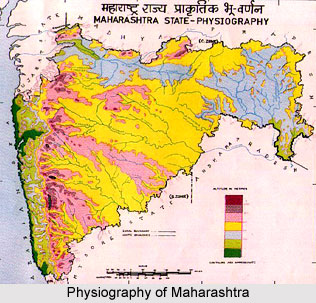
 Physiography of Maharashtra
Maharashtra is placed at
18` 96° north to 72` 82° east. The state of Maharashtra is divided into five river basins and two other regions of
Deccan Plateau and the coastal areas of Konkan coast. Maharashtra`s total area measures about 3, 07, 731 square kilometres.
| 1. Basins of West Flowing Rivers |
| a) Konkan River Basin |
| b) Tapi River Basin |
| c) Narmada River Basin |
| 2. Basins of East Flowing Rivers |
| a) Krishna River Basin |
| b) Godavari River Basin |
| 3. Deccan Plateau |
| 4. Coastal Strip of Konkan Coast |
Climate of Maharashtra
.
Maharashtra`s climate is mainly cold, hot and rainy. The hill stations located in this state do not experience extremes of climate and are not drastically chilly. Seasonal weather conditions sometimes lead to the formation of frost, hail and dew. Summers, monsoons and winters are the main seasons.
The months of March, April and May are generally the hottest months. The temperature hovers around 22 degree to 39 degree Celsius during summer. Thunderstorms are often witnessed during this time in Maharashtra. Rainfall commences in the very first week of the month of June. Monsoons continue from June to August. Monsoon departs from September onwards.
Temperatures drop to about 12 degree Celsius to 34 degree Celsius in the months of winter, namely from November to February. Cold, dry spells accompanied with pleasant breeze are present during the winter season. The districts of
Ratnagiri, Thane, Raigad and
Sindhudurg receive heavy rainfall measuring about 200 cms per year. However, the districts of
Pune, Ahmednagar, Nasik, Solapur, Sangli, Jalgaon, Satara, Jhule and portions of
Kolhapur receive less than 50 cms of annual rainfall. The
Sahyadris Mountain range and the coastal areas of Konkan get adequate rainfall. The central part of Maharashtra gets comparatively lesser amount of rainfall. Eastern parts of Vidarbha receive sufficient quantity of rainfall especially in the months of July, August and September.
Physiography of the western regions of India is varied, and comprises the distribution of annual rainfall, climate and physical topography.
 Indian physiography of the Western Regions implies the physical traits of the different portions of the country which lie in the western states of Rajasthan, Gujarat and Maharashtra. The diversity in Indian climates and regional geography has given birth to unique topographical features, climate, water resources and other physical divisions in Western India.
 Physiography of Gujarat
 Physiography of Maharashtra


