 Patiala District is one of the famous princely states of erstwhile Punjab. Patiala, an erstwhile princely state, capital of PEPSU and a district headquarters of Punjab are situated in the Malwa region of Punjab. Geographically, Punjab is divided into four regions known as Malwa Majha, Doaba and Puadh. Patiala district falls in the Puadh region and standard dialect spoken in the district is known as Puadhi. Although this dialect is almost same as the standard dialect of Punjabi language, the distinguishing character of this dialect is that, to a very large extent, it is influenced by Hindi spoken in the adjoining districts of Haryana. Patiala District occupies an area of 3625 sq kms. It was the 5th largest district of Punjab after Ferozepur District, Amritsar District, Sangrur District and Ludhiana District as per 2001 census but with the formation of Mohali District, Dera Bassi became a part of Mohali district. Earlier Dera Bassi tehsil was part of Patiala district.
Location of Patiala District
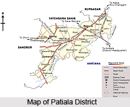
Forming the south-eastern part of the state, Patiala District lies between 29 degree 49 minutes and 30 degree 47 minutes north latitude, 75 degree 58 minutes and 76 degree 54 minutes east longitude. This administrative district of Punjab is surrounded by districts of Fatehgarh Sahib and Rupnagar and the Union Territory of Chandigarh in the north, Sangrur District in the west, Ambala and Kurukshetra districts of Haryana in the east and Kaithal district of Haryana in the south.
History of Patiala District
As per the history of Patiala District, it was founded by Ala Singh, who assumed leadership of the region in 1714 AD. Further it has been stated in the history of Patiala District that this region expanded into a big state under the rule of Ala Singh. Ala Singh fought courageously against the Mughals, Afghans and Marathas, and successfully founded the state. It was in the year 1763 he laid the establishment of Patiala fort, which is known as Qila Mubarak.
 Geography of Patiala District
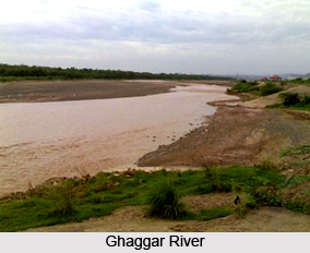
Geography of Patiala District forms a part of the Indo Gangetic plain and consists of three types of region - Upland Plain, Cho-infested Foothill Plain and Floodplain of the Ghaggar River. Apart from this, the district has a complex drainage system consisting of canals and rivers. River Ghaggar is the most important water channel of the district. It is essentially a seasonal stream, remaining dry during most part of the year. However, during the rainy session, it remains in spate, often flooding the adjoining villages. A number of subsidiary rivulets join the Ghaggar River. Apart from the natural drainage line, the district also has three important canals - Bhakra Main Line canal, the Nawana Branch, and the Ghaggar Link. These canals provide much needed irrigation water to the district. The climate of Patiala District is typical of Punjab plain that is very hot in summer and very cold in winter. The district is generally dry and hot, with monsoon lasting for three months. Both summer and winter are severe. The annual average rainfall is 688 mm. May is the hottest month with the mean monthly maximum temperature of 43.1 degree Celsius. January is the coldest month with mean monthly minimum temperature of 2.1 degree Celsius.
Demography of Patiala District
As per 2001 census, an overwhelming 65 percent lived in rural areas and only 35 percent lived in urban areas. Patiala District having a population of 18,44,934 is the 6th most populated district of the Punjab after Amritsar District, Ludhiana District, Gurdaspur District, Sangrur District and Jalandhar District according to 2001 Census.
Economy of Patiala District
Agriculture is the main source of economy of Patiala District. Out of geographical area of 3, 72,000 hectares, 3, 03,000 hectares (around 81 percent) is cultivable. 93 percent of the area is irrigated through tube wells and 3 percent by canals. There are around 62,090 agricultural families in the district. Wheat, barley, paddy, maize and sugarcane are major crops of the district. With over 65 percent of the population living in rural areas, 38 percent of the population depends on agriculture. Further, economy of Patiala District also includes certain industries. Patiala is fast emerging as an important industrial growth centre of the state. Besides traditional goods, high quality and sophisticated items are now produced including small cutting tools, power cables, bicycles and agriculture implements, milk products, pesticides, etc. The industrial units are scattered all over the district mainly at Rajpura, Dera Bassi, Patiala, Samana and Nabha.
 Education in Patiala District
Patiala District has been the cultural and academic centre of northern India. The erstwhile rulers of Patiala were great patrons of art and culture. Thus under the Maharajas, Patiala had developed into an important educational centre. It was the first city in this part of the country to have a degree college- the Mohindra College, established in the year 1870. This city has the credit of setting up the first printing press in Punjab - the famous Printing Press of Munshi Naval Kishore and for manufacturing the first Punjabi Typewriter. Today, Patiala District is an important seat of learning with a full-fledged University, a Government Medical College, a Dental College, an Ayurvedic College and an Engineering College. Other important colleges of the district are Guru Gobind Singh Bhawan, Thapar Institute of Engineering and Technology, Khalsa College, Govt. College for Women, Govt. Ayurvedic College, Govt. College, Govt. Ripudaman College, Public College, Samana and more.
Tourism in Patiala District
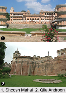
Patiala District is one of the popular tourist places of the state. Some of the main places of interest offered by this district to explore are Qila Mubarak Complex, Qila Androon, Shahi Samadhan, Moti Bagh Palace, Sheesh Mahal, Rajindera Kothi, Bir Moti Bagh and Lachman Jhoola. These places are worth visiting.
Patiala District represents a brilliant spectrum of Rajput, Mughal and Punjabi cultures.


