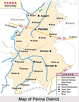
 Panna district is one of the most beautiful districts in the state of Madhya Pradesh. This district is also known for its temples which strikes a very fine blend of Hindu and Muslim architecture. Panna is the most sacred pilgrimage for the followers of the Pranami sect all over the world. With a sanctuary for rare wild life and fauna and a diamond mine, Panna has transformed a royal past into a vibrant and lively present. The Panna district is divided into 5 revenue blocks in which there are 1048 villages and 6 towns. Panchayat-wise, Panna has one Zila Panchayat and five Janpad Panchayats.
History of Panna District
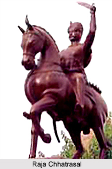
Steeped in the splendour of the royal legacies of its valuable past, Panna is reverentially mysterious, infectious, enveloping and holy place in Madhya Pradesh. The oldest reference to the district of Panna is in the great Hindu Epic of Ramayana and a number of Indian Puranas. The ancient name of Panna was "Padmawati-Puri", mentioned in Vishnu Purana and Bhavishya Purana. In the 41st sarg (Canto) of Ramayana written by Valmiki, it is described as Kilkila-Khand by Sugreeva and Shrimad Bhagwat calls it Kilkila Pradesh. According to Indian Mythology, it was the capital of Raja Dadhichi and also of Raja Padmavat during Satyayug. Swami Pran Nathji told Maharaja Chhatrasal of Bundela, a great medieval warrior regarding Diamond mines of Panna and thus strengthened his financial position. He also persuaded Chhatrasal to make Panna his capital and arranged his coronation there.
Panna district of today has been carved mainly out of former princely states of Panna and Princely State of Ajaigarh. Originally a Gond Tribe settlement up to the 13th century, it was raised to importance by Raja Chhatrasal Bundela who made it his capital. From explorations, it is proved that primitive men inhabited the district of Panna in the earlier pre-historic period. During the Ramayana period, the Panna region seems to have been included in the great Dandkaranya (Vast forest land includes the Abujhmar Hills in the Western Ghat and the Eastern Ghat in the east, including parts of the Chhattisgarh, Orissa, Maharashtra and Andhra Pradesh states). The district was the part of the vast Maurya Empire, Sunga Dynasty and Gupta Empire. From the middle of the 10th century AD to the second half of the 13th century, the kingdom of Chandella dynasty included Khajuraho, Kalingar and Ajaigarh. When the Bundelas came to power in the 17th century, the area came to be known as Bundelkhand.
Geography of Panna District
Panna district is situated in the northeastern parts of Madhya Pradesh state. It forms the northern district of Sagar Commissionerate Division. The district extends between 23 degrees 45 minutes and 25 degrees 10 minutes in the North Latitudes and between 79 degrees 45 minutes and 80 degrees 40 minutes in the East Longitudes. The shape of the Panna district is roughly triangular. From Bhopal, the capital of Madhya Pradesh, Panna is about 500 kilometres by rail route (up to Satna District), around 400 kilometres by road and around 40 kilometres by air route. The nearest airport is Khajuraho, the world famous heritage. Khajuraho is directly connected to the national capital, New Delhi by air. Khajuraho airstrip is only 45 kilometres from Panna. The nearest Railway station is Satna. It is directly connected to Bhopal, Jabalpur and Delhi and from Satna it is situated at a distance of 70 kilometres.
 Demography of Panna District
The Population Census in 2011 revealed that Panna District had population of 1,016,028 of which male and female were 532,866 and 483,162 respectively. The population of Panna District constituted 1.40 percent of total population of Madhya Pradesh. The population density of Panna district is 142 people per sq. kilometres. Panna district administers 7,135 square kilometres of areas.
Education in Panna District
The average literacy rate of Panna District was 66.08 percent. The male and female literacy rates were 75.63 and 55.55 respectively. The total literates in Panna District were 565,120. The male and female literacy rates were 339,312 and 225,808 respectively. There are private and government colleges in Panna and most of them have humanities as one of the subjects. The government as well as private bodies run schools in this district. Government schools are clustered into groups and the centre of the group is a Higher Secondary or a High School under which a number of middle and primary schools come. There are 229 middle schools, 834 primary schools, 237 vocational schools, etc.
Economy of Panna District
Though famous for its rich Diamond mines, the district of Panna is industrially a backward district and hence the State Industries Department has placed it in the `C` category. The District Industries Centre has established small-scale industrial areas at Satna Naka Panna and Udyog Giri Puraina Panna. Most of the inhabitants in Panna District earn their livelihood in engaging themselves in stone mining. While the others are engaged in making Coal Brackets, Chlorinated Paraffin Box, Ice, Edible Oil, Agricultural Implements, etc.
Tourism of Panna District
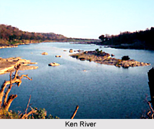
Panna is well-known for its diamond mines, stylish and huge temples, spectacular seasonal waterfalls, Panna National Park, Param dham for the Pranamies, Archaeological Museum, Fort, Palaces, Lord Jagannath Ratha Yatra, picturesque View points, etc. Panna is the twenty-second Tiger Reserve of India and fifth in the state of Madhya Pradesh. It is located in the Vindhya Mountain Ranges and spreads over Panna district and Chhatarpur district in the north of the state. The Ken River, which flows through the Reserve, is a home for Gharial, Maggar, and other aquatic fauna.
 The dominant architectural schemes of most of the temples are uniformly homogenous. After the decline of Mughal Dynasty, Muslim architectural wisdom appears in these temples. The domes of these temples are both plain and onion shaped. These temples have kalasha on the top. Most of the tallest domes have a lotus form.
The district of Panna is having several waterfalls and scenic views. It is situated on Vindhya Mountain Range, which gives this district a number of beautiful sites which include Pandava Fall, Brihaspati Kund, Nand-Chand, Nachne, etc. Pandav Fall is around 12 kilometres from Panna towards Khajuraho. Lush green surrounding makes the fall spectacular. At the foot of fall there are some ancient caves overlooking a large pool of water. About 100 feet high, the fall has a beautiful picnic spot. The Gatha fall is situated on the other side of the highway. This fall is very impressive, imposes during monsoon, and presents a very pleasant sight from the road itself.


