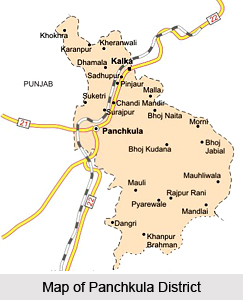
 Panchkula District is one of the 21 administrative districts of Haryana. Panchkula is a planned city and is the district headquarters. Panchkula District is surrounded by Himachal Pradesh in the north and east, by Punjab and Chandigarh in the west and by Ambala District in the south as well as in the east. Panchkula District shares its borders with Chandigarh, Mohali, Ambala District and Solan. Hindi language and Punjabi language are the main languages spoken in Panchkula. Haryanvi language being the state language is widely used here. There are five major towns in the district named Panchkula, Barwala, Pinjore, Kalka and Raipur Rani. The only hill station in Haryana called Morni is also in this district.
History of Panchkula District
As per the history of Panchkula District, the district derived its name from five irrigation canals. The region is also associated with the Pandavas. Panchkula District was under the Gupta Dynasty, and then it came under the rule of Chauhans and subsequently under the Ghoris. The region was also ruled by the Mughals and Marathas before the British rule. Panchkula District was formed on August 15th, 1995.
Geography of Panchkula District
Panchkula District has a sub tropical continental monsoon climate. The main seasons of this district are summer, winter and monsoon season. This district experiences a great variation in temperature within 0 degree Celsius to 43 degree Celsius. In winter frost sometimes occurs during the months of December and January. Panchkula District also receives winter rains from the western disturbances.
 The rainfall is mostly received in the monsoon season. Morni hills constitute the highest point of the district as well as of Haryana. Ghaggar River is the only perennial river. The other important rivers or streams of the district are Ghaggar, Sirsa and Kaushalya. Generally the slope of Panchkula District is from north east to south west and in this direction most of the rivers or rain fed torrents flow down. Only Sirsa River, in Kalka Tehsil, flows towards northwest through the region. The soils in the district are mainly light loam and clayey. The under ground water in the district occurs under confirmed and semi-confirmed conditions which is generally fresh and suitable for domestic and irrigation purposes. The under ground water level is generally high in the southern parts and low in north and northeast of Panchkula District which is hilly tract. The district lies in a region where earthquakes of moderate to high intensity have been felt in the past. It is prone to earthquakes.
Administration of Panchkula District
Administrative set-up of Panchkula District has two sub-divisions namely Panchkula and Kalka. The sub-tehsils of this district are Barwala, Morni Hills and Raipur Rani. Administration of Panchkula District has four development blocks and these are Barwala, Pinjore, Morni and Raipur Rani. Administration is headed by a Deputy Commissioner.
Economy of Panchkula District
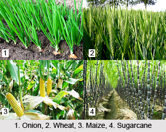
The present district of Panchkula has a mixed type of economy. In the district around 29.78 percent of its main workers are engaged in agricultural activities. The proportion of the main workers engaged in household industry is 1.83 percent in the district against 2.18 percent for Haryana. The percentage of main workers in manufacturing, processing servicing and repair (other than household industry) is nearly 13.26 percent in Panchkula District. The proportion of main workers in construction, trade and commerce, transport, storage and communications is relatively high in the district than the state figures. Panchkula town of the district had made rapid progress in the field of industrial development since it came into existence on 3rd of July 1989. The district now has a prominent place in the industrial map of Haryana. It also keenly promotes animal husbandry, fisheries and forestry, which plays a subsidiary but an important role in agricultural economy. Irrigation in the district mainly depends on tube wells. The percolation wells are also located in plain areas where sub-soil water is not too low. The major Kharif crops are sugarcane, paddy and maize while minor or subsidiary crops are chilies, pulses, vegetables, etc. The major Rabi crops are wheat, gram, barley and oilseeds while minor Rabi crops are barseem, methi, onion and other winter vegetables.
The present district of Panchkula remained industrially backward particularly till the beginning of the twentieth century. Its manufacturing units were few and unimportant.


