Home > Indian History > Geography of India > Pachaimalai Hills
Pachaimalai Hills
Pachimalai hills are a part of the Eastern Ghats in Tamil Nadu. Pachimalai is a beautiful place which exhibits some of the captivating waterfalls.

Share this Article:

Pachaimalai Hills, Tamil Nadu
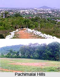
Pachimalai hills also known as the `Pachais` are a part of the Eastern Ghats. The hills are located in the southern state of India, Tamil Nadu. The hills are spread over the districts of Tiruchirapalli, Salem and Perambalur. The towns nestled in the hills are Thuraiyur, Esanai, Perambalur, Gangavalli, Thammampatti, Arumbavur, Malayalappatti, Thedavur and Uppiliapuram.

Etymology of Pachimalai Hills
Pachai in Tamil means `green` and malai means `mountain`. The Pachimalai hills are greener than some of the hills located nearby.

Attractions of Pachimalai Hills
Pachimalai is a beautiful place with unique culture and way of life. There are many native tribes inhabiting the hills. Among them the Malayali tribe is involved in the trade of some of the surplus agricultural products, which grow in the hills, to towns below on the plains for items not available in the hills.

The rivers flowing through the hills are Kallar and Sweata Nadi. The Veeraramar Dam is located in the hills across the Kallar River. The waterfalls in the hills include Mangalam Aruvi, Koraiyar Falls and Mayil Uthu Falls. The most cultivated fruit in the hills is jackfruit.

These hills offer fine opportunity to plunge into adventurous activities like trekking and swimming. The government of Tamil Nadu is planning to take various initiatives to improve the condition of the hills. The idea is to promote tourism and attract tourists from all parts of the world.

Connectivity of Pachimalai Hills
The hills are well connected to Trichy and Perambalur and these places are well connected to rest of India via train and air.

This article is a stub. You can enrich by adding more information to it. Send your Write Up to content@indianetzone.com


Share this Article:

Related Articles

More Articles in Geography of India


Geography of Uttar Pradesh
The fourth largest State in India UP is located in the Northern part of India whose area is 2,36,286 sq Kms.
Geography of Maharashtra
Covering an area of 308,000 sq. km, Maharashtra, the third largest state in India.
Geography of Kerala
Geography of Kerala includes plains, hills, valleys and coasts. With the Arabian Sea in the west, the Western Ghats in the east and networked by several rivers, Kerala enjoys diverse geographical features.
Geography of West Bengal
The geography of West Bengal is unique with high peaks of the Himalayan range in the north, the Bay of Bengal in the south and the remaining region is covered with both plains and plateaus.
Geography of Jharkhand
Geography of Jharkhand is comprised of the rich mineral resources and the highly agricultural prospect in this state.
Geography of Sikkim
Geography of Sikkim is characterised by a vast array of magnificent hillock that extends from one corner of the state to the other.
Geography of Meghalaya
The suitable climate, highland plateaus, rivers and the flora and fauna together forms the geography of Meghalaya.
Geography of Mizoram
Mizoram is surrounded by hills, valleys, rivers, waterfalls and lakes. The hills range from 1000 meters to 2000 meters. Rivers, lakes and waterfalls also play major role in forming the land of Mizoram.
Geography of Jammu & Kashmir
Jammu and Kashmir is encompassed by valleys. Some of the dominant valleys of the state are Kashmir Valley, Tawi Valley, Chenab Valley, Poonch Valley, Sind Valley and Lidder Valley etc. Jhelum River is the only major Himalayan River which flows through the Kashmir valley. Indus, Tawi, Ravi and Chenab Rivers are the major ones flowing through the region.
Geography of Daman and Diu
Daman and Diu is situated on the west coast of India and are the smallest union territories of India.
Geography of Goa
Geography of Goa occupies a prime location along the Konkan coastal belt on the western coast of India. The state is bordered by Maharashtra in the north and Karnataka in the south. The Western Ghats in the east contribute to the flora and fauna of Goa.
Geography of Arunachal Pradesh
Geography of Arunachal Pradesh reveals that it is a hilly tract nestled in the foot of Himalayas.
Geography of Kutch
Geography of Kutch District is covering an area of 45,612 km. Kutch District is the largest district in the state of Gujarat.
Geography of Ladakh
Geography of Ladakh mainly comprises the huge Karakoram Range with long stretch of cold desert which mark the region separately from the rest of the states of Indian subcontinent. Surrounded with the mountain ranges from all corners this small region separates Indian subcontinent from rest of the Asian continent.
Geography of Rajasthan
Geography of Rajasthan defines the dry topography with arid climate of the western mountain region.
Geography of Tamil Nadu
The Indian state of Tamil Nadu is located in the Northern hemisphere in the hot zone.