 River Kaveri originates in the Brahmagiri hills in Kodagu. This place is called Talakaveri or the head of Kaveri. The river starts its journey from the small pond called as Kundike pond, the two tributaries known as Kanake and Sujyoti joins it later in the course. All these three rivers meet at the point called Bhagamandala. It lies at an altitude of 1350 meters and generally flows from the direction of south to the eastward direction. The river has an approximate length of 760 km. It flows in the state of Karnataka and Tamil Nadu and finally merges into Bay of Bengal. The major tributaries of the river Kaveri include Shimsha river, Arkavathy river, Honnuhole river, Hemavati river, Lakshmana Tirtha river Kabini river, Bhavani river, Lokapavani river and the Amaravati river.
River Kaveri is among the most sacred rivers of India and hailed as the Dakshina Ganga or Ganga of the South. Mythology has several statements and references about Kaveri`s tumble onto the earth. The most popular is that a king by the name of Kavera, residing in the Brahmagiri hills, prayed to Lord Brahma for an offspring. He was blessed with a daughter whom he named Kaveri. She was the water expression of the human form.
The great sage Agastya married her and contained her in his kamandalu (spouted jug). When a disastrous drought affected the land, Ganesha in the disguise of a crow, tipped the kamandalu and out flowed Kaveri.
A river like Kaveri is not just a stretch of water. It is an active, living and poignant force. The river is life-visible and invisible; it can create or destroy stretches of land. Poets and artists have to develop an intimacy with her before picking up their pens and brushes; engineers have to study her respectfully before building bridges and dams; and those living on the banks are extremely devoted to the River Kaveri.

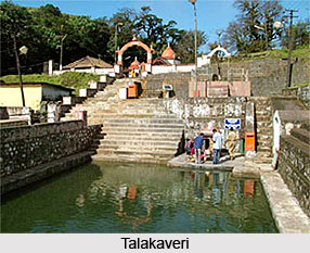
Talakaveri is the particular spot where the River Kaveri originates. This is the origin of river Kaveri on the eastern slopes of Brahmagiri peak at the height of 1350 metres altitude, about 8 km by road from Bhagamandala region. An enclosure around the spring is called the Gundige and is connected to a small pond beside. The water from the pond goes deep underground and comes out after about one kilometer downwards the hill. There are three shrines situated above the spring and birds eye view of west coast from the hill range.
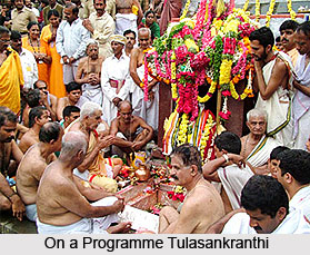
On a programmed date and time of Tulasankranthi every year the spring from Gundige overflows called Thirthodbhava. This holy water is carried home by all pilgrims when they go back after paying the last rituals to their parent or partner died in the previous year. There is a shrine near the kundike of Kaveri river and a big tank in front of it where devotees baths before offering prayers to the Goddess. There are 2 temples here, a Shiva temple with a exceptional and ancient Shiva Linga, and another Lord Ganesha`s temple. According to legend, the Trimurtis - Brahma, Vishnu and Mahesh gave darshan or their appearance to sage Agastya at the holy Ashwantha tree near the temple.
Mythology also has it that every year on Tulasankramana is the day which falls approximately on 17 October Goddess Parvati appears in the Kundike as the sacred teerthodbhava. This occasion is symbolized by the sudden spring of water in the kundike and is considered to be very auspicious.
From Talakaveri, plentiful steps lead up to the nearby Brahmagri peak. It is believed that the 7 great sages called the Sapta Maharishis had executed a special yagna here. From the peak, as well as on the drive to Talakaveri, the tourists can enjoy a good view of the misty blue Brahmagiri hills.


