 Gangotri is the place of origin of the revered River Ganga. Ganga is the most sacred of the Indian rivers. Ganges is the source of sustenance of life in the great Indian plains and it is at Gangotri that the remarkable journey of Ganga begins. Indian mythology tells the story of the birth of Ganges. King Bhagirath pleaded to Lord Shiva and was granted his wish that Goddess Ganga comes down on earth to bring to life his expired ancestors.
 The river was said to have been entangled in Lord Shiva`s locks, to save the earth from destruction. Gaumukh near the Gangotri glacier looks like a cow`s head and strangely, the river flows down at great speed through this natural formation, without which it would have been hard to retain and was sure to have caused devastation. Due to its obvious importance to Hinduism, Gangotri is one of the most famous pilgrimage sites in India. This place has reached the peak of tourism in Uttarakhand. There are several tourist spots in Gangotri; some of them are as follows:
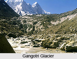
Gangotri Glacier
The Gangotri glacier happens to be the origin of the Bhagirathi River. The glacier is 30 kilometers long and between 2 to 4 kilometers wide. It is located in the Uttarkashi district in the northern Indian state of Uttarakhand, near the border of China. It is a significant pilgrimage site for the Hindu devotees as well as trekkers who come here to take a dip in the waters near the glacier. Due to global warming, the glacier is often observed to be diminishing. The journey though strenuous is worth it, in ways more than one.
Gaumukh
This is considered to be the accurate source of the Bhagirathi River- the main channel that forms the sacred Ganga River along with some more rivers. The place looks like a cow`s mouth and offers stunning natural beauty along with spiritual significance.
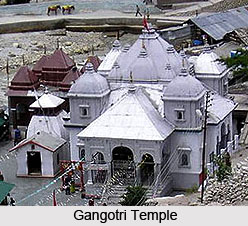
Gangotri Temple
A Gurkha commander Amar Singh Thapa built this temple in the 18th century. The temple has an attractive white marble structure about 20 feet high. During the winter months, the statue is moved away to the nearby Mukhimath village and is kept there for the next six months.
The Shiva Linga
The submerged Shiva Linga is a phallic form of Lord Shiva and is visible only during winter when the water levels are low enough. This is believed to be the exact spot where Lord Shiva had entangled the river in his locks.


