 Nilgiris district due to its natural charm and pleasant climate was a place of special attraction for the Europeans. In the year 1818, Mr. Whish and Kindersley, who were assistants to the Collector of Coimbatore, discovered the place Kotagiri near Rengaswamy Peak. John Sullivan, the then Collector of Coimbatore was very much interested in this part of the country. He founded his residence there and reported to the Board of Revenue on the 31st of July 1819. The name `Nilgiris` means Blue hills. The first mention of this name has been found in the Shilapaddikaram. There is a belief that the people living in the plains at the foot of the hills, should have given the name, the Nilgiris, according to the violet blossoms of `Kurinji`, flower enveloping the hill ranges periodically. According to the 2001 census, the population of this south Indian district is 762141 and the total literacy rate of this district is 80.01 percent.
History of Nilgiris District
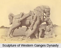
The earliest reference to the political history of the Nilgiris relates to the Ganga Dynasty of Mysore. Immediately after the Nilgiris was ceded to the British in the year 1789, it became a part of Coimbatore district. In the month of August 1868, the district of Nilgiris was separated from the Coimbatore district. James Wilkinson Breeks took over the administration of the Nilgiris as its Commissioner. In the month of February 1882, the Nilgiris was made a district and a Collector was appointed in the place of the Commissioner. On the 1st of February 1882, Richard Wellesley Barlow, who was the then Commissioner, became the First Collector of Nilgiris.
Geography of Nilgiris District
The district of Nilgiris in the Indian state of Tamil Nadu is spread over an area of 2452.50 square kilometres.The Nilgiris district is located at an elevation of nine hundred to two thousand six hundred and thirty six meters above the mean sea level. The district of Nilgiris is bounded by the state of Karnataka to the North, the district of Coimbatore and Erode to the West, the district of Coimbatore and the state of Kerala to the South and the state of Kerala to the East. In the Nilgiris district, the topography is rolling and steep. About sixty percent of the land under cultivation falls under the slopes ranging from sixteen to thirty five percent.
 This district normally receives rain both during South-West monsoon and North-East monsoon. The entire Gudalur and Pandalaur, Kundah taluks and portion of Udhagamandalam taluk receive rain by the South-West monsoon and some portion of Udhagamandalam taluk and the entire Coonoor and Kotagiri taluks receive rain from the North-East monsoon.
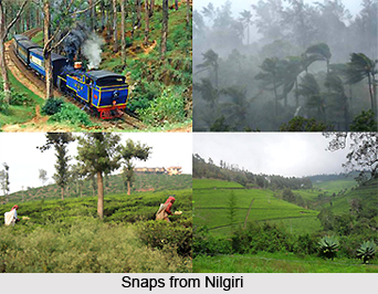
Due to the location of the Nilgiris at an elevation of nine hundred to two thousand six hundred and thirty six meters, the climate of this district during summer remains to the maximum of 21 degree Celsius to 25 degree Celsius and the minimum of 10 degree Celsius to 12 degree Celsius. In winter, the temperature goes up to a maximum from 16 degree Celsius to 21 degree Celsius and to a minimum of two degree Celsius. There are no irrigation schemes in the Nilgiris district and the crops grown here are mainly rain fed. The Nilgiris district is mainly a Horticulture District and the entire economy of the district depends upon the success and failure of Horticultural crops like Carrot, Potato, Cabbage, Coffee, Tea, Spices and Fruits.
Administration of Nilgiris District
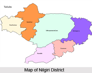
The Nilgiris district comprises six taluks including Udhagamandalam, Coonoor, Kundah, Kotagiri, Pandalur and Gudalur. These taluks are divided into four Panchayat Unions. These Panchayat unions are Udhagamandalam, Kotagiri, Coonoor and Gudalur. There are two municipalities, which are Wellington Cantonment and Aruvankadu Township. This district of Tamil Nadu state consists of fifty six Revenue Villages and fifteen Revenue Firkas. Two Revenue Divisions are there in the district including Coonoor and Gudalur. There are thirty five Village Panchayats and thirteen town Town Panchayats in this district.
Tourism in Nilgiris District
The district of Nilgiris is a very famous tourist destination in the state of Tamil Nadu in India and people from different parts of the country and also from outside the country visits this district throughout the year. Udhagamandalam, the headquarters of the Nilgiris district, is the largest and most important hill station in south India. This principle station on the Nilgiris is at an elevation of two thousand two hundred and eighty six meters and located at the centre of the district. It is an extensive valley enclosed on all sides but the west by a lofty range of hills. The name `Ooty` or `Ootacamand` was first mentioned in about 1821 in the Madras Gazette which was then spelt as `Wotokymund` by an anonymous correspondent. Ooty is also fondly called the Queen of Hill Stations. The major attractions of Ooty are Government Botanical Garden, Centenary Rose Park, Ooty Lake, Doddabetta Peak, The Ootacamand Club, Raj Bhavan, Adam`s Fountain, Honey and Bee Museum, The Ooty Radio Telescope, Kamaraj Sagar Dam, Glenmorgan, Avalanche, Pykara Lake, etc.

Coonoor stands on a lower ridge of the plateau at an altitude of one thousand eight hundred and fifty eight meters and has a railway station on the Mettupalayam-Udhagamandalam route. Coonoor is an important trade centre for tea and the Tea Board of India has a branch office at this place.
Kotagiri is one of the oldest and the largest hill stations of this district which is about thirty kilometres to the east of Udhagamandalam, twenty three kilometres from Coonoor and thirty three kilometres from Mettupalayam. This hill station is protected by the Doddabetta Peak from the violent south-west monsoon and is not affected by mists which are very common at Coonoor. Some of the major attractions are the Longwood Shola, Catherine Falls, Kodanad View Point, Rangasamy Pillar and Rangasamy Peak, etc.


