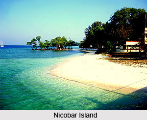
 The Nicobar Islands are an island chain in the eastern Indian Ocean. These islands belong to the Union Territory of Andaman and Nicobar Islands, India. Nicobar Islands are located southeast of the Indian subcontinents that are separated by the Bay of Bengal by about 1,300 km. The Nicobar Islands are situated south of the neighboring Andaman Islands archipelago, about 189 km northwest of the Indonesian island of Sumatra.
Indira Point, the southernmost point of India, is located on these islands (Great Nicobar). The Nicobars include 22 islands of various sizes, the largest being Great Nicobar. The total land area of the chain is around 1841 km². The highest point on the Nicobar Islands is Mount Thullier on Great Nicobar Island at 642 m. The population of the Nicobar Islands was 42,026 in 2001. Roughly 65% of these are indigenous peoples include the Nicobarese and Shompen peoples, who are included among the Scheduled Tribes of India and 35% have ethnic origins from the Indian mainland and the island of Sri Lanka.
The Nicobar Islands cluster into three groups. The northern group includes Car Nicobar (127 km²) and Batti Malv (2 km²). The latter one is uninhabited, and a nationally designated wildlife sanctuary. The central island includes Chowra, Teressa, Poahat, Trinket, Katchal, Camorta, Nancowry, Isle of Man and Tillangchong. The last two islands are both uninhabited, with Tillangchong being a designated wildlife sanctuary. Southern group of Island includes Great Nicobar, Kondul, Little Nicobar, Pulomilo, Meroe, Trak, Treis, Menchal, Kabra, Pigeon and Megapod - all of which are uninhabited islets, with Megapod being a designated wildlife sanctuary.
The Nicobar Islands are part of the Andaman and Nicobar Islands, a Union Territory of India. The capital of the Andaman and Nicobar Islands territory is Port Blair on South Andaman Island. The Union Territory is dissected into three districts, North and Middle Andaman district, South Andaman district and Nicobar district. The Government presently requires access to the Nicobar Islands after a special permit (Tribal Pass) and, in general, non-Indian citizens are forbidden from visiting the Nicobar Islands except Campbell Bay. Nicobar Pigeon is one of the migratory birds found only in the Nicobar Islands and parts of Indonesia.
The Nicobar Islands are part of a great island arc that is created by the collision of the Indo-Australian Plate with Eurasia. The collision lifted the Himalayas and most of the Indonesian islands, and created a long arc of highlands and islands, which includes the Arakan Yoma range of Myanmar, the Andaman and Nicobar Islands, and the islands off the west coast of Sumatra, including the Banyak Islands and Mentawai Islands. The climate of Nicobar Islands is warm and tropical, with temperatures ranging from 22 to 30°C. Rainfall is heavy in this Island due to annual monsoons and measures around 3000 to 3800 mm each year. The vegetation of the Nicobar Islands is typically divided into the coastal mangrove forests and the interior evergreen and deciduous Tropical and subtropical wet broadleaf forests. Additionally, several islands of the Nicobar group contain extensive interior grasslands, though these are thought to result from human intervention.
 The Nicobar Islands are recognized as a distinct terrestrial eco-region, the Nicobar Islands rain forests, with many endemic species. As a result of lower sea levels during the ice ages, the Andaman Islands were linked to the Southeast Asian mainland, but it is not understood that the Nicobar Islands ever had a land bridge to the continent. Lower sea levels connected the islands to one another, namely the Great Nicobar and Little Nicobar were linked to each other, and Nancowry, Chaura, Katchall, Trinka, Camorta, and the nearby smaller islands were linked to one another as well.
The Nicobar Islands were inhabited for thousands of years. Six indigenous Nicobarese languages are spoken on the islands, which are a part of the Mon-Khmer branch of the Austroasiatic language family and include Mon, Khmer and Vietnamese languages of Southeast Asia, and the Munda languages of India. An indigenous tribe living at the southern tip of Great Nicobar, called the Shompen, may be of Mesolithic Southeast Asian origin. The name `Nicobar` is was derived from the Chola dynasty name for these islands, Nakkavaram (literally meaning naked man in Tamil) that is inscribed on the Tanjore inscription of 1050AD.
The history of organised European colonization on the Nicobar Islands started with the Danish East India Company in 1754. Between 1778 and 1783, Austria tried to establish a colony on the islands on the mistaken guess that Denmark had abandoned its claims to the islands. Danish involvement ended officially on 16 October 1868 when the Danish rights to the Nicobar Islands were surrendered to Britain, which made them part of British India by 1869 when the British took possession. The islands were occupied by Japan between 1942 and 1945. Together with the Andaman Islands, they became a union territory of India in 1950.
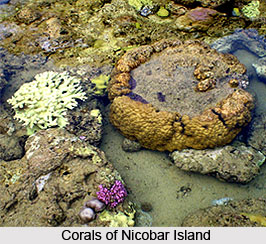
On 26 December 2004 the coast of the Nicobar Islands was devastated by a 10-15 m high tsunami following the 2004 Indian Ocean earthquake. At least 6000 people were believed to have died on the Andaman and Nicobar Islands during the disaster. Reports said death toll on Katchal Island alone to be at 4,600. Several islands were heavily damaged with initial reports of islands broken in two or three pieces and coral reefs floated above water. Teressa Island was split into two pieces and Trinkat Island into three pieces. Some estimates said that the islands were moved as much as 100 feet (30 m) by the earthquake. Indira Point went beneath sea level and its light station and crew missing. More than two months after the disaster of tsunami on Nicobar Islands, no contact had been made with seven bands totaling about 150 of the 389 total Shompen. On July 24th, 2005, a strong earthquake, measuring 7.2 on the Richter scale, struck the Nicobar Islands but fortunately there was no instant report of death or destruction.


