Home > Indian History > Geography of India > Nanda Devi East Peak
Nanda Devi East Peak
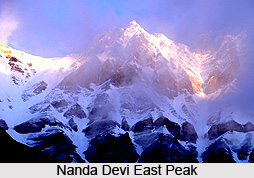
Nanda Devi East Peak is a part of the Nanda Devi Peak in the Garhwal Himalayas.

Share this Article:

Nanda Devi East Peak, Mountain Peak of IndiaNanda Devi East Peak is a part of the Nanda Devi Peak in the Garhwal Himalayas. It is one of the highest mountains in the Indian Himalayas. Nanda Devi East beautifully stands in the centre of a ring of peaks. It exactly lies on the eastern edge of the ring at the border of districts Chamoli, Pithoragarh and Bageshwar.

Expeditions on Nanda Devi East Peak
This peak was first climbed in the year 1939 by a four-member Polish expedition led by Adam Karpiski. They climbed the south ridge of Nanda Devi East Peak, from Longstaff Col; this is still the standard route on the peak. The summit party was Jakub Bujak and Janusz Klarner. Karpiski and Stefan Bernadzikiewicz died later in an attempt on Trishuli.

The first attempt to traverse the ridge between the main summit and Nanda Devi East brought about the unfortunate death of two members of a French expedition in 1951. Team leader Roger Duplat and Gilbert Vignes disappeared on the ridge somewhere below the main summit. Tenzing Norgay belonged to the support team on this expedition; he along with Louis Dubost climbed Nanda Devi East to look for the missing pair. Some years later Tenzing was asked what was the most difficult climb he ever did, expecting him to say Mount Everest; he surprised his interlocutors by mentioning Nanda Devi East.

An Indo-French East-West Traverse expedition, back for some unfinished business, in 1975 successfully put several members on both the peaks of Nanda Devi East Peak but the navigation remained unconsummated until the following year. Chamonix climbers Walter Cecchinel, Dorjee Lhatoo and Yves Pollet-Villard climbed the Nanda Devi East Peak and unroped from Camp IV.

In 1981, an Indian Army expedition followed the same line. Phu Dorjee Sherpa, a climbing instructor from the Himalayan Mountaineering Institute and his partner fell from the vicinity of the final ice field. It is assumed that they are summited. The standard approach to the south ridge route, from the Milam Valley to the east, passes through Lawan Glacier via Lawan Gad and thence to Longstaff Col. The trek to base camp of Nanda Devi East Peak goes through the villages of Munsiyari, Lilam, Bogudiar, Martoli, Nasanpatti, and Bhadeligwar. An alternate route of Nanda Devi East Peak climbs the southwest face, from a base camp inside the Sanctuary.


Share this Article:

Related Articles

More Articles in Geography of India


Geography of Uttar Pradesh
The fourth largest State in India UP is located in the Northern part of India whose area is 2,36,286 sq Kms.
Geography of Maharashtra
Covering an area of 308,000 sq. km, Maharashtra, the third largest state in India.
Geography of Kerala
Geography of Kerala includes plains, hills, valleys and coasts. With the Arabian Sea in the west, the Western Ghats in the east and networked by several rivers, Kerala enjoys diverse geographical features.
Geography of West Bengal
The geography of West Bengal is unique with high peaks of the Himalayan range in the north, the Bay of Bengal in the south and the remaining region is covered with both plains and plateaus.
Geography of Jharkhand
Geography of Jharkhand is comprised of the rich mineral resources and the highly agricultural prospect in this state.
Geography of Sikkim
Geography of Sikkim is characterised by a vast array of magnificent hillock that extends from one corner of the state to the other.
Geography of Meghalaya
The suitable climate, highland plateaus, rivers and the flora and fauna together forms the geography of Meghalaya.
Geography of Mizoram
Mizoram is surrounded by hills, valleys, rivers, waterfalls and lakes. The hills range from 1000 meters to 2000 meters. Rivers, lakes and waterfalls also play major role in forming the land of Mizoram.
Geography of Jammu & Kashmir
Jammu and Kashmir is encompassed by valleys. Some of the dominant valleys of the state are Kashmir Valley, Tawi Valley, Chenab Valley, Poonch Valley, Sind Valley and Lidder Valley etc. Jhelum River is the only major Himalayan River which flows through the Kashmir valley. Indus, Tawi, Ravi and Chenab Rivers are the major ones flowing through the region.
Geography of Daman and Diu
Daman and Diu is situated on the west coast of India and are the smallest union territories of India.
Geography of Goa
Geography of Goa occupies a prime location along the Konkan coastal belt on the western coast of India. The state is bordered by Maharashtra in the north and Karnataka in the south. The Western Ghats in the east contribute to the flora and fauna of Goa.
Geography of Arunachal Pradesh
Geography of Arunachal Pradesh reveals that it is a hilly tract nestled in the foot of Himalayas.
Geography of Kutch
Geography of Kutch District is covering an area of 45,612 km. Kutch District is the largest district in the state of Gujarat.
Geography of Ladakh
Geography of Ladakh mainly comprises the huge Karakoram Range with long stretch of cold desert which mark the region separately from the rest of the states of Indian subcontinent. Surrounded with the mountain ranges from all corners this small region separates Indian subcontinent from rest of the Asian continent.
Geography of Rajasthan
Geography of Rajasthan defines the dry topography with arid climate of the western mountain region.
Geography of Tamil Nadu
The Indian state of Tamil Nadu is located in the Northern hemisphere in the hot zone.