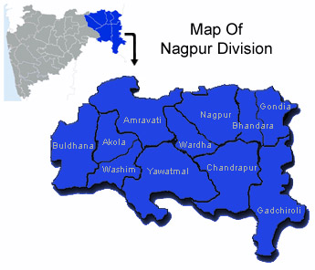
 The Indian state of Maharashtra is thronged with various towns, places, locales and divisions. Nagpur Division is the name of one of the 6 administrative divisions of the state. Amongst all the six divisions this Nagpur division is situated in extreme east. Nagpur city has earned the status of being an administrative headquarter. it is situated on along the Nag river, almost at the geographic centre of India.
The history of Nagpur division has got an interesting story behind it. Founded by the Gond prince in the 18th century, it became the capital of members of the Maratha confederacy. Nagpur Division was formed in the year 1861 when Central Provinces of British India were formulated with the merging of Nagpur Province and the Saugor and Nerbudda Territories.
Before that, Nagpur Division was integrated to Nagpur Province, which has been taken over by the British in the year 1853. At that time Balaghat District has been a part of Nagpur Division. In the Post independence era Central Provinces along with Berar (Amravati Division) became part of newly formed Madhya Pradesh state. In the year 1956 when all the states of India were regrouped along linguistic lines, Nagpur and Amravati Divisions fall under Bombay State. It was done on 1st November of the same year. Balaghat District came under Madhya Pradesh. In the year 1960 areas with Marathi-speaking people was part of the Bombay State. It covers an area of 51,336 sq. km.
The Census report of the year 2001 throws some light on the demographical traits of Nagpur division. As per this report the total population of Nagpur Division has been enumerated to be 10,665,939. Its literacy rate also is no less insignificant. It comprises of several districts like Chandrapur, Bhandara, Gadchiroli, Gondia, Nagpur, Wardha.
Irrigational activities are done in an area of 4,820 sq. km of the same Nagpur Division.
