Home > Indian History > Geography of India > Nagarjuna Sagar Tail Pond Project
Nagarjuna Sagar Tail Pond Project
Nagarjuna Sagar Tail Pond Project is constructed at downstream of Nagarjuna Sagar Dam, across River Krishna in Andhra P

Share this Article:

Nagarjuna Sagar Tail Pond Project is a hydro-mechanical works at 21.065Km downstream of Nagarjuna Sagar Dam. This dam is constructed across River Krishna near Satrasala (V) of Guntur District in Andhra Pradesh. The Damaracharla village of Nalgonda District lies very close to this dam and is highly benefited from this Dam. The Rural Electrification Corporation had given the loan sought for the purpose.
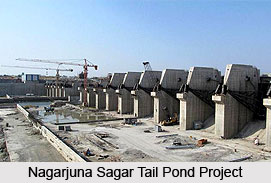
Nagarjuna Sagar Tail Pond Project, Andhra Pradesh The Nagarjuna Sagar Tail-Pond Dam, popularly known as the TPD, has been kept in cold storage for long and is of high importance in the APGenco`s agenda for doing justice to the people of Telangana. The dam project proved to be of a great benefit for the Krishna delta.

The three other projects taken up for the Pulichintala delta and the two Godavari-Krishna links are the first one bringing 85 TMCFT from Polavaram to Prakasam Barrage, and the second one 200 TMCFT from Dummagudem to Nagarjuna Sagar.

According to the finalized design made, the TPD was constructed on the Krishna at Satrasala, 21 km below Nagarjuna Sagar but its reservoir was extended upto Nagarjunasagar to store 6 TMCFT. However, only one TMCFT was allotted for the reversible turbines of Nagarjuna Sagar powerhouse. But the entire pond was allowed to be emptied for supplementing the Krishna delta. TPD was mainly used to put the main powerhouse`s reversible turbines into use. The powerhouse has eight units. The pond was mechanized in a way to allow seven reversible turbines to pump waters back into Nagarjuna Sagar.

Telangan did not use the water recycled into Nagarjuna Sagar from TPD exclusively, though it was projected likewise. After joining the reservoir, the water can be used for the Right Bank Canal or for power generation. Each of the main powerhouse`s turbines consumes 120 MW of power to work in reverse direction, which means one-and-a-half times its original capacity, 100 MW.


Share this Article:

Related Articles

More Articles in Geography of India


Geography of Uttar Pradesh
The fourth largest State in India UP is located in the Northern part of India whose area is 2,36,286 sq Kms.
Geography of Maharashtra
Covering an area of 308,000 sq. km, Maharashtra, the third largest state in India.
Geography of Kerala
Geography of Kerala includes plains, hills, valleys and coasts. With the Arabian Sea in the west, the Western Ghats in the east and networked by several rivers, Kerala enjoys diverse geographical features.
Geography of West Bengal
The geography of West Bengal is unique with high peaks of the Himalayan range in the north, the Bay of Bengal in the south and the remaining region is covered with both plains and plateaus.
Geography of Jharkhand
Geography of Jharkhand is comprised of the rich mineral resources and the highly agricultural prospect in this state.
Geography of Sikkim
Geography of Sikkim is characterised by a vast array of magnificent hillock that extends from one corner of the state to the other.
Geography of Meghalaya
The suitable climate, highland plateaus, rivers and the flora and fauna together forms the geography of Meghalaya.
Geography of Mizoram
Mizoram is surrounded by hills, valleys, rivers, waterfalls and lakes. The hills range from 1000 meters to 2000 meters. Rivers, lakes and waterfalls also play major role in forming the land of Mizoram.
Geography of Jammu & Kashmir
Jammu and Kashmir is encompassed by valleys. Some of the dominant valleys of the state are Kashmir Valley, Tawi Valley, Chenab Valley, Poonch Valley, Sind Valley and Lidder Valley etc. Jhelum River is the only major Himalayan River which flows through the Kashmir valley. Indus, Tawi, Ravi and Chenab Rivers are the major ones flowing through the region.
Geography of Daman and Diu
Daman and Diu is situated on the west coast of India and are the smallest union territories of India.
Geography of Goa
Geography of Goa occupies a prime location along the Konkan coastal belt on the western coast of India. The state is bordered by Maharashtra in the north and Karnataka in the south. The Western Ghats in the east contribute to the flora and fauna of Goa.
Geography of Arunachal Pradesh
Geography of Arunachal Pradesh reveals that it is a hilly tract nestled in the foot of Himalayas.
Geography of Kutch
Geography of Kutch District is covering an area of 45,612 km. Kutch District is the largest district in the state of Gujarat.
Geography of Ladakh
Geography of Ladakh mainly comprises the huge Karakoram Range with long stretch of cold desert which mark the region separately from the rest of the states of Indian subcontinent. Surrounded with the mountain ranges from all corners this small region separates Indian subcontinent from rest of the Asian continent.
Geography of Rajasthan
Geography of Rajasthan defines the dry topography with arid climate of the western mountain region.
Geography of Tamil Nadu
The Indian state of Tamil Nadu is located in the Northern hemisphere in the hot zone.