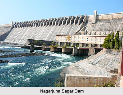
 Built across Krishna River in Nagarjuna Sagar, the Nagarjuna Sagar Dam is a stonework dam in Andhra Pradesh. This dam is known to be the world`s tallest masonry dam, at a height of 124 metres. The reservoir can hold water up to 11, 472 million cubic metres.
Nagarjuna Sagar Dam is one of the earliest irrigation and hydroelectric projects in India. The dam is the prime source of irrigational water to the Nalgonda District, Khammam District, Prakasam District and Guntur District.
The then Prime Minister`s daughter, Indira Gandhi in 1967, inaugurated the functions of the dam and released the water. The construction of the dam unfortunately, submerged an ancient Buddhist settlement, Nagarjunakonda. This was the capital of the Ikshvaku dynasty in the 1st and 2nd centuries. The successors of the Satavahanas in the Eastern Deccan settled in this settlement. Excavations here had yielded the remains of 30 Buddhist monasteries, as well as inscriptions and art works of great historical importance. Before the incident of the reservoir flooding, the monuments were dug up and relocated; some of them were shifted to Nagarjuna`s Hill. This hill is now an island in the middle of the reservoir. The other monuments were moved to the mainland.
In February 1956, the project started but modern equipment could not be bought due to scarcity of funds. The project was finally constructed with stone instead of concrete. A cement factory was build near Macherla to meet the project requirement. A railway line was laid that connected the project location and the cement factory. Sunkesula quaries situated very close to the project supplied stones. Rayavaram stream and Halia River were the suppliers of sand. The construction of the dam was completed by 1969.
The Nagarjuna Sagar Dam was started at its complete form from 1972 after fitting the huge crest gates. Two canals were constructed to supply water from this reservoir, one on right and other on the left. Total expenditure on the project including maintenance till 2005 was approximately 1300 crore rupees. The number of workers labored in the project varied from 45,000 to 70,000. During the construction, around 174 people died due to accidents.
The Nagarjuna Sagar Dam project benefited farmers in the districts of Guntur, Prakasam, Krishna, Nalgonda and Khammam. The right canal is the Jawahar canal, which is 203 km long and irrigates 1.113 million acres (4,500 km²) of land. The left canal or the Lalbahadur Shastri canal is 295 km long and irrigates 1.03 million acres (4,200 km²) of land. The project changed the economy of the mentioned districts. 52 villages were drowned in water and 24000 people were homeless. The rehabilitation of the people was completed by 1967.
The Nagarjuna Sagar Dam is also an important hydro electric plant of the state and has a power generation capacity of 815.6 MW with 8 units (1x110 MW+7x100.8 MW). First unit was sanctioned on 7th March 1978 and 8th unit on 24th December 1985. The right canal plant has a power generation capacity of 90 MW with 3 units of 30 MW each. The left canal plant has a power generation capacity of 60 MW with 2 units of 30 MW each.
The catchment area of the Nagarjuna Sagar Dam is 215000 Sq km or 83012 sq mi. The masonry dam constituted of the spillway of dam (471 m) and non-over flow dam (979 m). The length of masonry dam is 1450 m and the maximum height is 125 m. The total length of the earth dam is 3414 m and the height is 26 m.


