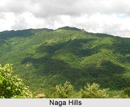
 Naga Hills is part of the complex mountain barrier on the border of India and Myanmar (Burma). The hills are located in India extending into Myanmar. It forms a divide between India and Myanmar. They are part of a complex mountain system, and the parts of the mountain ranges inside the Indian state of Nagaland and the Burmese region of Sagaing are called the "Naga Hills". The highest point of Naga Hills is Mount Saramati (3826 m). In British India, the major part of the hills came under the Naga Hills district.
A northern extension of the "Arakan Yoma" system, the Naga Hills reach a height of 12,552 feet (3,826 m) in Mount Saramati on the India-Myanmar frontier. The part of the range within India constituted the Naga Hills district of Assam until 1961 and since 1963 has been part of Nagaland. The Naga Hills join the sub-Himalayan ranges in the north. The Naga Hills are actually part of Indian Territory mountain ranges of Arakan Mountains between the western Burma and the Naga Hills district. Naga Hills is one of the major tribal regions of Nagaland state and inhabited by Naga people.
History of Naga Hills
A part of the Naga Hills under the British Indian control was coalesced into a district in 1866. The boundaries of the Naga Hills District were gradually expanded by annexation of the territories of several Naga tribes, including the Aos (1889), the Semas (1904) and the Konyaks (1910). In 1912, the district was made part of Assam province. Following the Partition of India, it was merged with the Tuensang Division to create the state called Nagaland in 1963.
Geography of Naga Hills
The hills are not very large in its span and have very few rivers, which are very small in length and breadth till when they are within their local territory. The rivers are not navigable in any season; deep valley navigation is impossible due to the rocky terrain. It is shocking that there are no lakes or waterfalls in these hills, though there are few but they dry up in short time. The hills receive a heavy monsoon rainfall and are naturally clothed with dense forest. Placed throughout the hills are villages of the Naga tribes.
Fauna of Naga Hills
The birds that usually can be noticed in the Naga Hills are Black Partridge, Spotted Dove, Hoopoe, White Vulture, Common Peafowl, Grey Partridge, Malabar Pied Hornbill, Blue Rock Pigeon etc. Among the animals the most common are: Wild Boar, Barking Deer, Himalayan Black Bear, Pangolins, Porcupines, Wild Goat, Jackal, Jungle Cat, Royal Bengal Tiger, Wolf, Leopard, Land Tortoise and other Snakes.
Vegetation of Naga Hills
The vegetation of the Naga Hills is basically tropical, sub-tropical evergreen forests. Main produce from the forests include Palm, Mahogany, Bamboo and Timber. The society is basically agrarian. Rice, Corn, Millets, Pulses etc apart from Oilseeds, Arums, Yams, Maize, Sugarcane and Potatoes are produced.


