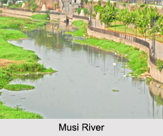
 Musi River is a tributary of Krishna River and flows in the Deccan Plateau region of Andhra Pradesh state in India. It flows through the main regions of Hyderabad and separates the notable old city with the new city. Musi River is also known as "Nerva" during Qutub Shahi period. Normally, it is a contracted and smooth stream flowing through the city, but it was famous for causing destruction and loss of life when it floods.
Course of Musi River
Musi River begins in Anantagiri Hills near Vicarabad, Rangareddi district, 90 kilometers to the west of Hyderabad and joins Krishna River near Wazirabad in Nalgonda district after covering a distance of about 240 km.
Bridges on Musi River
There are many bridges constructed across the Musi River in Hyderabad city. The oldest bridge is called "Purana Pul", which literally means the "old bridge". The Qutb Shahi sultans of Golconda built it during the 16th century. "Naya Pul" or the "new bridge" is made near High court. The other bridges are located in Dabirpura, Amberpet Chaderghat and Uppal Kalan.
Flood by Musi River
Musi River is also known for its frequent flood devastation in the Hyderabad city till the early years of 20th Century. On Tuesday 28th September 1908 Hyderabad experienced catastrophic floods of the River Musi, flowing across the city. In one day, 17 inches of rainfall was once recorded and the water level at Afzalgunj was around 11 feet (3.4 m) high and in some other places it was even higher. These floods traumatized the life of the people living in Hyderabad.
Dams on Musi River
Many examinations have been done giving recommendations on preventing a recurrence of floods and also improving civic amenities. Nizam VII constituted a City Improve Trust in 1912. He built a flood control system on the river to prevent the flooding. A dam was built in 1920 across the river, 16 km upstream from the city called "Osman Sagar". In 1927 another dam was built on Esi (tributary of Musi) and named "Himayat Sagar". These dams checked the flooding of the River Musi and are major drinking water sources for Hyderabad city. Hussain Sagar Lake was built on a tributary of the River Musi. It was a lake of 24 kilometres, built to meet the water and irrigation needs of the city.
Pollution on Musi River
Now due to random urbanization and lack of planning the river has become a holder of all the unprocessed domestic and industrial waste drained out of Hyderabad. It is estimated that nearly 350 MLD (Million Litres a Day) of polluted water and sewage originating from the twin cities of Hyderabad and Secunderabad finally flow into the river. Numerous efforts are made to clean it but all have failed. The river water in the middle and lower courses within the city is highly polluted.


