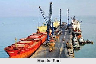
Mundra Port dons a mantle of a 4000-year historical legacy of Gujarat`s maritime glory. Today, Mundra once more opens up India`s most natural gateway to the world. Mundra Port is a fully commercial and professionally managed multi-purpose port making the optimum utilization of all the resources, potential and abilities available. Its comprehensive range of maritime services is continuously enhanced to serve customers satisfactorily. Mundra Port has practiced a comprehensive and integrated development philosophy in the areas of marine structures, backup storage area, cargo handling facilities, and logistics, within the port with a single window operating system for the customer`s satisfaction.
 Mundra Port, the most advanced customer specialist port, is the only port in the country which offers state-of-the-art port services, including stevedoring, storage and cargo transfer (mechanized cargo handling), etc. under one umbrella. Mundra is the largest private port in India, capable of handling more than 100 million tonnes of bulk, liquid or containerized cargo. Mundra Port is situated almost 10 Kms far from Mundra city. There are two ports: (1) Old Port (2) Adani Port. These ports are used the whole year. Today, these ports have much traffic of many large ships and steamers of world. These ports have a very bright future. Many people come from other states to work here. Mundra is also known for dry date `Kharek`. `Kharek; is exported to the other states. Mundra Port is an integral part of the Mundra SEZ. The SEZ status confers significant benefits to the developers and business partners of the port, thus providing cost-efficient solutions to the end-customers.
Mundra port is ideally located to access the Asian, European, American, South American and African Markets. Moreover, Mundra has an attractive and large hinterland spread over Western, Northern and North Eastern India covering 70% of India`s GDP. Mundra Port is 435 kms closer to Delhi than JNPT Mumbai Port. Since the advent of the Port, the area has attracted numerous large industries and is all set to become a high-productivity industrial belt. The Port has a privately developed 64 km rail line which is connected to the nearest railhead at Adipur. The Bhuj airport and Kandla airstrip are a short drive away. The port has its own 1900 meters aerodrome equipped with latest navigational instruments for landing of private executive jets. Mundra Port is a comprehensive Service Provider with state-of-the-art facilities.
Mundra Port Management has an ambitious plan of increasing capacity to 50 million ton by 2010. Long term development plans include waterfront for an additional 14 Berths Basin, which can handle Capsize Vessels. A dedicated Coal terminal at Wand is planned.


