Home > Indian History > Geography of India > Mountain Peaks of North East India
Mountain Peaks of North East India
Mountain Peaks of North East India have not only beautified this region, but have also contributed in making it a tourist destination of India.

Share this Article:

Mountain Peaks of North East IndiaThe states of Arunachal Pradesh, Manipur, Meghalaya, Mizoram, Nagaland, Tripura and Sikkim are located in the north eastern part of India. North East India has several mountain peaks existing as a part of its geographical terrain. They have not only beautified the states in North East India, but have also contributed in making this region a tourist destination of India.

Mountain Peaks of Arunachal Pradesh
The state of Arunachal Pradesh has several mountain peaks. Tani Razi is the highest mountain of Arunachal Pradesh. It has a height of about 15,022 ft (4,579 m). Some of the other mountain peaks of Arunachal Pradesh are Kelingon (14,319 ft / 4,365 m), Komdi (12,688 ft) and Romta (7,964 ft / 2,428 m).

Mountain Peaks of Manipur
The state of Manipur is adorned with a number of mountain peaks. Laikot is the highest mountain of Manipur. It has a height of about 8,413 ft (2,564 m). Other mountain peaks of Manipur are Siruhi Kashong (7,235 ft / 2,205 m), Rasibung (3,923 ft / 1,196 m) and Lungpon Ching (3,431 ft / 1,046 m).

Mountain Peaks of Meghalaya
Maryngksih is known to be the highest mountain in the state of Meghalaya. It has a height of about 5,002 ft (1,525 m). Another mountain peak in Meghalaya is Sherpai (4,913 ft / 1,498 m).

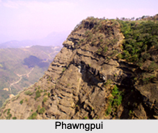
Mountain Peaks of Mizoram
Nauzuarzo Tlang is the highest mountain of the state of Mizoram. It has a height of about 5,671 ft (1,729 m). The other mountain peaks of Mizoram are Phawngpui (5,453 ft / 1,662 m), Vapar Tlang (5,333 ft / 1,626 m), Lungreng Tlang (4,541 ft / 1,384 m), Diltang (2,502 ft / 763 m) and Khan Tlang (1,795 ft / 547 m).

Mountain Peaks of Nagaland
The state of Nagaland is adorned with mountain peaks namely, Mol Len (9,016 ft / 2,748 m), Yakko (7,681 ft / 2,341 m) and Dazipfu (6,934 ft / 2,114 m). Mol Len is regarded as the highest mountain of Nagaland.

Mountain Peaks of Tripura
Jari Mura is the name of the Mountain Peak located in Tripura. It has a height of about 1,265 ft (386 m).

Mountain Peaks of Sikkim
The state of Sikkim has a number of mountain peaks. Jongsong Peak is known to be the highest mountain of Sikkim. It has a height of about 24,482 ft (7,462 m). Some of the other mountain peaks of Sikkim are Tent Peak (24,154 ft / 7,362 m), Siniolchu (22,598 ft / 6,888 m) and Chameringu (13,341 ft / 4,066 m).


Share this Article:

Related Articles

More Articles in Geography of India


Geography of Uttar Pradesh
The fourth largest State in India UP is located in the Northern part of India whose area is 2,36,286 sq Kms.
Geography of Maharashtra
Covering an area of 308,000 sq. km, Maharashtra, the third largest state in India.
Geography of Kerala
Geography of Kerala includes plains, hills, valleys and coasts. With the Arabian Sea in the west, the Western Ghats in the east and networked by several rivers, Kerala enjoys diverse geographical features.
Geography of West Bengal
The geography of West Bengal is unique with high peaks of the Himalayan range in the north, the Bay of Bengal in the south and the remaining region is covered with both plains and plateaus.
Geography of Jharkhand
Geography of Jharkhand is comprised of the rich mineral resources and the highly agricultural prospect in this state.
Geography of Sikkim
Geography of Sikkim is characterised by a vast array of magnificent hillock that extends from one corner of the state to the other.
Geography of Meghalaya
The suitable climate, highland plateaus, rivers and the flora and fauna together forms the geography of Meghalaya.
Geography of Mizoram
Mizoram is surrounded by hills, valleys, rivers, waterfalls and lakes. The hills range from 1000 meters to 2000 meters. Rivers, lakes and waterfalls also play major role in forming the land of Mizoram.
Geography of Jammu & Kashmir
Jammu and Kashmir is encompassed by valleys. Some of the dominant valleys of the state are Kashmir Valley, Tawi Valley, Chenab Valley, Poonch Valley, Sind Valley and Lidder Valley etc. Jhelum River is the only major Himalayan River which flows through the Kashmir valley. Indus, Tawi, Ravi and Chenab Rivers are the major ones flowing through the region.
Geography of Daman and Diu
Daman and Diu is situated on the west coast of India and are the smallest union territories of India.
Geography of Goa
Geography of Goa occupies a prime location along the Konkan coastal belt on the western coast of India. The state is bordered by Maharashtra in the north and Karnataka in the south. The Western Ghats in the east contribute to the flora and fauna of Goa.
Geography of Arunachal Pradesh
Geography of Arunachal Pradesh reveals that it is a hilly tract nestled in the foot of Himalayas.
Geography of Kutch
Geography of Kutch District is covering an area of 45,612 km. Kutch District is the largest district in the state of Gujarat.
Geography of Ladakh
Geography of Ladakh mainly comprises the huge Karakoram Range with long stretch of cold desert which mark the region separately from the rest of the states of Indian subcontinent. Surrounded with the mountain ranges from all corners this small region separates Indian subcontinent from rest of the Asian continent.
Geography of Rajasthan
Geography of Rajasthan defines the dry topography with arid climate of the western mountain region.
Geography of Tamil Nadu
The Indian state of Tamil Nadu is located in the Northern hemisphere in the hot zone.