 Morigaon District is an administrative district of Assam. This district is bounded by Brahmaputra River in the north, in the south by Karbi Anglong District, in the east by Nagaon District and by Kamrup District in the west. Morigaon District is an agrarian district. It is situated between 26.15 degrees north and 26.5 degrees north latitude and between 92-degree East longitudes. Morigaon town, headquarter of the district is located at 78 kilometres from Dispur. This district is the second smallest district of Assam. Morigaon District was a sub-division of Nagaon district since 26th January 1972. Morigaon District occupies a total area of near about 1450 sq km.
History of Morigaon District
History of Morigaon District is unclear. Writing of Bhimsingh throws some light on the history of Morigaon town and its neighbouring areas. The six rulers ruled this region independently. Two princes from Darrang, Supradhvaj and Makardhvaj, fled from their homeland due to internal clash, by crossing the Brahmaputra River and they settled at Bahakajari. Later on, Supradhvaj married the daughter of Mangal Singh, the King of Baghara. Supradhvaj was then made the seventh king of the region, having an independent kingdom of his own. Further, two other princes from Darrang District, Ram Singh and Bhimsingh crossed the Brahmaputra in search of plain lands. Bhim Singh ultimately Brahmaputra and settled down near Mori Beel. This place thus came to known as Morigaon.
Geography of Morigaon District
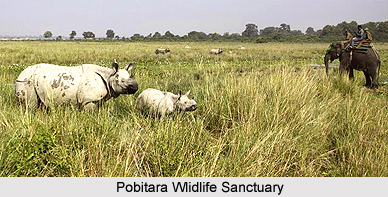
Greater part of Morigaon District is an alluvial plains dotted with many beels and marshes, numerous rivers and waterways. Brahmaputra River flows along the northern boundary of the district. Killing, Kollong and Kapili rivers flow through the southern part of the district. Geographical features of Morigaon District indicate that its general appearance is extremely picturesque. There are three reserved forest constituted under Assam Forest Regulation Act, 1891. These are Sunaikuchi, Khulahat, and Bura Mayong. There is also one wildlife Sanctuary, named Pabitora Sanctuary, which is famous for the Indian one horned Rhinoceros.
Demography of Morigaon District
According to the Population Census in the year 2011, the Morigaon District had population of 957,853 of which male and female were 485,328 and 472,525 respectively. Morigaon District population constituted 3.07 percent of total population of Assam. The population density of Morigaon district for 2011 is 618 people per sq. km. The average literacy rate of Morigaon was 69.37 percent compared to 58.53 of 2001. If things are looked out at gender wise, male and female literacy were 73.66 and 64.99 respectively. The total literates in Morigaon District were 554,143 of which male and female were 297,422 and 256,721 respectively. In 2001, Morigaon District had 5,312,396 in its district.
Tourism in Morigaon District
Some of the main attractions of Morigaon District includes Pabitora Wildlife Sanctuary, Patekibori Than, Deosal, Kachasila Hill, Sitajakhala, and a Dry Fish Market (which is the largest in Asia).


