Home > Indian History > Geography of India > Mithi River
Mithi River
Mithi River is a seasonal river and a natural drainage channel, which carries the surplus water during the monsoon.

Share this Article:

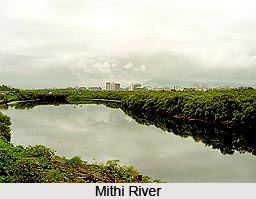
Mithi River, MumbaiMithi River is located in Salsette Island on which the Mumbai city is situated. It is also known as the Mahim River. The river is actually the merging of the tail water that is discharged from the Powai and Vihar Lake. It is a seasonal river, which feeds on the monsoons.

Geography of Mithi River
The river rises from the valley near the Sanjay Gandhi National Park at Powai and merges with the Arabian Sea at Mahim Creek. During its course, the river flows through residential and industrial complexes of Powai, Saki Naka, Kurla, Kalina, Vakola, Bandra-Kurla complex, Dharavi and Mahim for fifteen kilometres. The river is narrow in its initial course, which is nearly ten metres in width, but it widens gradually and is wide at the Bandra Kurla complex. The river is fourteen kilometres in length. The average width of the river in the upper reaches is 5 m. It has been widened to 25 m in the middle reaches and up to 70 m in the lower reaches after the 26 July 2005 deluge.

Ecology of Mithi River
The Mahim bay area where the Mithi River merges with the Arabian Sea is a bird sanctuary, which is called Salim Ali Bird Sanctuary. Many migratory birds visit the area. A dam has been constructed across this river along the upstream side of Vihar Lake. The river is a natural drainage channel, which carries the surplus waters during the monsoon.
Mithi River, MumbaiThreats to Mithi River
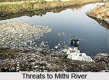
There are many threats to the water of Mithi. The dumping of raw sewage, industrial waste and municipal waste into the river highly pollutes the water. To make it worse, the barrel cleaners, scrap dealers and others dump sludge oil, effluent and garbage in the river. The water with mixture of sewage and industrial waste is a threat to marine life.

Efforts to Save Mithi River
Many young entrepreneurs in and around Mumbai are putting effort to create awareness and save the river. In the year 2009, environmentalist and Magsaysay Award winner, Rajendra Singh lead a yatra, of a group of environmentalist and NGOs, through Mumbai city along the endangered Mithi River to emphasize its problems.


Share this Article:

Related Articles

More Articles in Geography of India


Geography of Uttar Pradesh
The fourth largest State in India UP is located in the Northern part of India whose area is 2,36,286 sq Kms.
Geography of Maharashtra
Covering an area of 308,000 sq. km, Maharashtra, the third largest state in India.
Geography of Kerala
Geography of Kerala includes plains, hills, valleys and coasts. With the Arabian Sea in the west, the Western Ghats in the east and networked by several rivers, Kerala enjoys diverse geographical features.
Geography of West Bengal
The geography of West Bengal is unique with high peaks of the Himalayan range in the north, the Bay of Bengal in the south and the remaining region is covered with both plains and plateaus.
Geography of Jharkhand
Geography of Jharkhand is comprised of the rich mineral resources and the highly agricultural prospect in this state.
Geography of Sikkim
Geography of Sikkim is characterised by a vast array of magnificent hillock that extends from one corner of the state to the other.
Geography of Meghalaya
The suitable climate, highland plateaus, rivers and the flora and fauna together forms the geography of Meghalaya.
Geography of Mizoram
Mizoram is surrounded by hills, valleys, rivers, waterfalls and lakes. The hills range from 1000 meters to 2000 meters. Rivers, lakes and waterfalls also play major role in forming the land of Mizoram.
Geography of Jammu & Kashmir
Jammu and Kashmir is encompassed by valleys. Some of the dominant valleys of the state are Kashmir Valley, Tawi Valley, Chenab Valley, Poonch Valley, Sind Valley and Lidder Valley etc. Jhelum River is the only major Himalayan River which flows through the Kashmir valley. Indus, Tawi, Ravi and Chenab Rivers are the major ones flowing through the region.
Geography of Daman and Diu
Daman and Diu is situated on the west coast of India and are the smallest union territories of India.
Geography of Goa
Geography of Goa occupies a prime location along the Konkan coastal belt on the western coast of India. The state is bordered by Maharashtra in the north and Karnataka in the south. The Western Ghats in the east contribute to the flora and fauna of Goa.
Geography of Arunachal Pradesh
Geography of Arunachal Pradesh reveals that it is a hilly tract nestled in the foot of Himalayas.
Geography of Kutch
Geography of Kutch District is covering an area of 45,612 km. Kutch District is the largest district in the state of Gujarat.
Geography of Ladakh
Geography of Ladakh mainly comprises the huge Karakoram Range with long stretch of cold desert which mark the region separately from the rest of the states of Indian subcontinent. Surrounded with the mountain ranges from all corners this small region separates Indian subcontinent from rest of the Asian continent.
Geography of Rajasthan
Geography of Rajasthan defines the dry topography with arid climate of the western mountain region.
Geography of Tamil Nadu
The Indian state of Tamil Nadu is located in the Northern hemisphere in the hot zone.