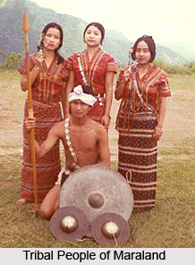
Mara Autonomous District Council or MADC is amongst the three Autonomous District Councils which is located in the Eastern Indian state of Mizoram. In the southern portion of Mizoram, along the borders of the nation of Myanmar, there exists an autonomous administrative government which is aimed to govern the regional people residing here. The total area occupied by Mara Autonomous district measures about 1, 445 square kilometres. The Mizo National Front or MNF was joined by Shri. N. Viakhu, who was the Independent Member of the District Council, on December, 2005.
 History of Mara Autonomous District
The land of the Maras has been surrounded by the country of Burma in the eastern and southern side and Lai Autonomous District Council in the western and northern side. Prior to the arrival of the British to India, Maras were independent and governed their land with the help of chiefs elected by them. During the British Raj, the Maras occupied the British Empire quite often. Repeated encroachments upon the British territories in India angered the British. Therefore, in the year 1924, the British annexed their areas. Mara chiefs and the British Superintendent ruled over the Maras. One portion of the land of Maras was partitioned and declared to be a part of the province of East Bengal after 20 years. Later, the Mara land underwent further partitions.
The people of the Mara land were referred to as `Lakhers` by the inhabitants of the Lushai Hills, or the Mizo tribes, while the Khumis and Arakanese called them `shendus` or `shindus`. The Mara people were termed as `Miram` by the Hakas, who were their neighbours to the north. The Chins preferred to call them as `Zo`. The Constituent Assembly of the Indian Constitution granted the status of Scheduled Tribe of India to the Maras in the year 1950.
Administrative System of Mara Autonomous District
Mara Autonomous District Council supervises numerous departments which involve forestry, education, Public Health Engineering (PHE), fisheries, judiciary, land and revenue, schools (particularly middle school) and some others. The government has control over some other regional powers, judicial administration, legislative powers and land administration. In 2009, Mara Autonomous District was administered by Shri. N. Viakhu. Viakhu was known to have organised the coalition government, along with Indian National Congress in the elections of 2005 and Maraland Democratic Front.
In the year 2012, the last election of MADC was organised wherein the Indian National Congress gained maximum seats of 15 out of an aggregate of 22. Shri RT Zachono, the present Chief Executive Member or CEM is an expert politician from the Constituency of Amotlah or Rawmibawk. Shri Hiphei, its Chairman is the former Member of Parliament in the Rajya Sabha.


