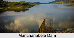
 Manchanabele Dam on Arkavathy River is one of the well known tourist spots situated in Manchibele village of Magadi Teluk of Bangalore. This site is located at a distance of 40 km from Bangalore in Karnataka. This is mainly known for the large reservoir and the dam which attract large variety of land birds. This place is an ideal spot for one day outing from Bangalore. Though the dam is not so large yet it provides great site for tourism. Surrounded with grasslands and greenery, this area attracts a large variety of land birds that migrate to this area in every season, which makes the area more attractive. This place is mainly located in the rural district of Bangalore surrounded by small villages. The main occupation of this village is farming.
Main Attractions of Manchanabele Dam
Along with the attractive dam and picturesque reservoirs, the area also attracts the tourists towards the age old Banyan tree which is located at the outskirts of the nearby village. The route to reach the banyan tree travels through the dam. Manchanabele Dam is situated in the midst of the hills and forests of Savana Durga which is one of the largest monoliths of Asia. Surrounded by some low lying hills, Manchanabele Dam also excites its visitors with adventures of trekking and hiking. Low in height, this dam is surrounded with large reservoir of back waters. There is an ancient local temple as well that stands at the bank of the Arkavathy River. In a cloudy atmosphere, this site provides great opportunity for photography and boating.
Avifauna in Manchanabele Dam
Along with its back water reservoir, this site is also well known for the bird sanctuary. Unlike other bird sanctuaries in Karnataka this place attract some types of birds which prefer to fly in dry seasons as well. Some of the birds which are mostly observed in this area are Marsh Harrier, Blue Kingfisher, Oriental Honey Buzzard, Brahminy Straling, Common Tailorbird, Ringed Plover, Purple Heron and Little Cormorants, Doves, Booted Wobbler, Indian Roller, Bulbul, Jerdon`s bushlark, Pied Bushchat and many more.
Visiting Information to Manchanabele Dam
Nearest airport to reach this site is in Bangalore and nearest railway station is also in Bangalore. From Bangalore it will take approximately 2 hours to reach the Manchanabele Dam.


