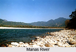
 The Manas River is a major tributary of the Brahmaputra River and flowing through Assam. It is named after "Goddess Manasa", the serpent God in Hindu mythology. The Manas River is a trans-boundary river in the Himalayan foothills between southern Bhutan and India. The river splits up at Mathanguri in India in to two major channels. It flows then through Assam for 104 km before it joins the mighty Brahmaputra River at Jogighopa which is located at a distance of around 90 km from the destination.
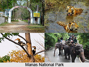
The river valley has two major reserve forest areas, namely the Royal Manas National Park in Bhutan and the contiguous Manas Wildlife Sanctuary encompassing Project Tiger reserve, an elephant reserve and a biosphere reserve, which constitutes a UNESCO World Heritage Site, declared in December 1985.
Course of Manas River
The total length of the river is 376 km flows through Bhutan for 272 km and then through Assam for 104 km before it joins the mighty Brahmaputra River at Jogighopa. Another major tributary of the Manas, the Aie River joins it in Assam at Bangpari. It is met by three other major streams before it again debouches into India in western Assam.
Geography of Manas River
The river valley in the foothills is surrounded by small meadows located among thickly deciduous forested foothills with many rivulets, streams and natural drainage channels related to the river system. In the lower reaches of the river, there are many smooth sandy stretches populated with trees.
The foot hills in Bhutan and India known as Terai and the Duars (a Sanskrit word meaning "passes" or "gates"), which encompass 15-30 km stretch of the foot hills and which are very fertile. The fertile lands have been developed into tea estates and paddy fields.
 Environmental threats of Manas River
The Manas River has often been the centre of environmental controversies, particularly in the 1980s. Two dams were proposed on the Bhutanese side of the river to provide hydroelectric power and to control the flow of the Brahmaputra on its northern bank and make way for irrigation schemes. The Ministry of Environment and Forests of India objected to the proposal on the grounds of adverse impact that would occur due to the dam on the hydrology and ecology of the area.
In February 1989, the All Bodo Students Union (ABSU) invaded the park and killed several wardens and guards, permitting the entry of poachers and loggers who posed an immediate threat to the wildlife of the park and its river. The threat of flooding remained as ever in 2010.
Reserved Areas of Manas River
Out of the large catchment of the river valley, protected or reserved areas have been specifically demarcated, both in Bhutan and India, which are declared national parks or sanctuaries.
•Royal Manas National Park: Royal Manas National Park in southern Bhutan, considered the national heritage of Bhutan, was declared a wildlife sanctuary in 1996 and subsequently raised to the status of a national park in 1993. The park is bounded on its north by the Black Mountain National Park and the Manas Tiger Reserve on its South in India.
•Manas Wild Life Sanctuary: The Manas Wild Life Sanctuary, located in Assam, is considered as one of "Asia"s finest wild life reserves" and is a UNESCO World Heritage Site. It now encompasses a bio reserve, a tiger reserve and also an elephant reserve. The park is well forested and also comprises grass lands and marshes. In 1928, the core of the area was designated a sanctuary and in 1978 it was declared a tiger reserve.
The park is well known for its rare and endangered endemic wildlife such as the tigers, elephants, Assam roofed turtle, hispid hare, golden and capped langurs and pygmy hog, one-horned rhinoceros, Asiatic buffalo, swamp deer, barking deers, leopards, clouded leopards, marbled cats, sloth bears, hillock gibbons, wild boar, gharials, crocodiles and river dolphins. Reptiles consist of pythons, common Indian crocodile, common wolf, snake, cat snake and many other species. Birds listed include hornbills, crane, common redshank, Eurasian woodcock, spotted eagles, black-throated diver, little grebe, different types of herons, black ibis, Eurasian sparrow hawk, spot-bellied eagle-owl and several others. The park is home for 22 endangered mammal species.


