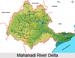
 Mahanadi River Delta is a large depositional basin of about 9000 sqkm, created by both sea and river, situated in the state of Orissa, India. Mahanadi River Delta is a basin of deposit that washes away a large landmass of the Indian subcontinent into the Bay of Bengal. The alluvial valley is quite wide and relatively flat with a twisting river channel that alters its course. This coastal tract between Eastern Ghats in the west and Bay of Bengal in the east created fertile land and ecosystem with rich biodiversity. The main River Mahanadi branches into many distributory channels, which have been depositing sediment and forming broad, flat alluvial plain. This is a perfect delta with a fan angle of about 140 degrees between two outermost distributaries i.e. River Birupa in north and River Devi in south. The Hirakud Dam has a 55-km long lake or reservoir alongside. The famous city of Puri is located at one of the distributory mouths.
Mahanadi River
The Mahanadi River begins in south-eastern Madhya Pradesh as a small stream draining the eastern part of the Chhattisgarh Plain, later it enters Orissa state below Baloda Bazaar and crosses the Eastern Ghats to enter the Plains of Orissa near Cuttack and finally empty into the Bay of Bengal through a series of channels after travelling almost 900 km. The Mahanadi River has an estimated drainage area of 141,464 sqkm. The river deposits more silt than almost any other river in the Indian subcontinent. Drainage density is extremely dense in this area. The interior coastal plain has a relatively low height. The average altitude of the drainage basin is 426 m, with a maximum of 877 m and a minimum of 193 m.
Population density in Mahanadi River Delta
The area is situated within 60 km from the coast line and holds the highest density of population in the state. The upper part of the Mahanadi River Delta plain is heavily populated. The population density exceeds 36 people per sqkm, although moving towards the coast the population density falls.
Climate around Mahanadi River Delta
Mahanadi River Delta falls under tropical climate. Rainfall comes principally from the summer monsoon, during the months from June to September. The average annual rainfall in the basin is 1,463 mm. Rainfall is recorded to be exceptionally low during the rest of the year, rarely exceeding 30 mm per month.
Nature of Mahanadi River Delta
The Mahanadi River Delta has always provided favourable condition for human habitation because of its rich productive soil and extensive water resources. The soil is rich comprising mostly coarse and fine loamy soils and coarse sandy soils and supports rich agriculture including paddy as the dominant crop, besides jute, pulses and grams.


