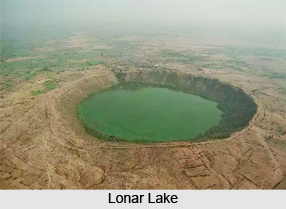
 Lonar Lake is a saline soda lake in India. It is not only one and only in India, but it is the world"s hyper-velocity impact crater.
Location of Lonar Lake
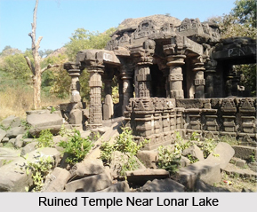
Lonar Lake located at Lonar in Buldhana district of Maharashtra. Near Lonar Lake, there are many temples constructed in the medieval era especially in Yadava Dynasty.
Creation of Lonar Lake
Lonar Lake was created by a meteor impact during the Pleistocene Epoch and it is the only known hyper velocity impact crater in basaltic rock anywhere on earth.
Lonar Lake in Historical Texts
Ain-i-Akbari which was written about 1600 CE states that the Western Ghats Mountain Range in India produce all the requisites for making glass and soap. And here are saltpetre works which yield a considerable revenue to the state, from the duties collected. On these mountains is a spring of salt water, but the water from the centre and the edges is perfectly fresh.
Geological Explanation on Lonar Lake
Lonar Lake lies within the only known extraterrestrial impact crater found within the great Deccan Traps basaltic formation of India. The lake was initially believed to be of volcanic origin, but now it is recognized as an impact crater created by the hypervelocity impact of either a comet or an asteroid. The presence of plagioclase that has been either converted into maskelynite or contains planar deformation features has confirmed the impact origin of this crater. It is argued that only shock metamorphism caused by hypervelocity impact can transform plagioclase into maskelynite. The presence of shatter cones, impact deformation of basalt layers comprising its rim, shocked brecciate inside the crater, and non-volcanic blanket surrounding the crater are further proof of the impact origin of Lonar crater. The crater of Lonar Lake has an oval shape. The meteorite impact came from the east, at an angle of 35 to 40 degrees.
Geography of Lonar Lake
Lonar Lake lies in a basalt impact structure, is both saline and alkaline in nature. Geologists, ecologists, archaeologists, naturalists and astronomers have published studies of various aspects of this crater lake ecosystem.
Extension of Lonar Lake
Lonar Lake has a mean diameter of 1.2 kilometres (3,900 ft) and is about 137 metres (449 ft) below the crater rim. The meteor crater rim is about 1.8 kilometres (5,900 ft) in diameter. The circular depression of Lonar Lake bears a saline water lake in its central portion. The crater`s age is usually estimated to be 52,000 to 60,000 years (Pleistocene), although a study published in 2010 gives an age of 570,000 to 4,70,000 years.
Natural Beauty of Lonar Lake
Lonar Lake has the beautiful natural landscape. There are the series of low hills surrounding the basin which has an oval shape (almost round) with circumference at top of about 8 km (five miles). The sides of Lonar Lake rise abruptly at an angle of about 75 degree. At the base, the lake has a circumference of about 4.8 km (three miles). The slopes are covered with tree-savannah, housing teak, Wrightia tinctoria, Butea monosperma, and Helicteres isora. Shrub-savannah with Acacia nilotica and Ziziphus spp. covers the crater wall. Along the lake shore, non-native Prosopis juliflora is spreading. The north-eastern alluvial terrace, along the dhara river fan, is used for agriculture. Millet, maize, lady`s finger, banana and papaya are the main cultivated crops.
Water of Lonar Lake
The water of Lonar Lake contains various salts or sodas, and during dry weather when evaporation reduces the water level, large quantities of soda are collected. Two small streams, named Purna River and Penganga River, drain into the lake, and a well of sweet water is located on the southern side, close to the water`s edge.
Related Articles
Resources in India
Water Resources in India
Lakes of India
Lakes of Telangana
Tarsar Marsar Lake
Western Ghats Mountain Range in India


