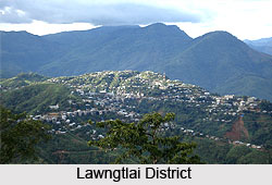
 Lawngtlai District is situated in the state of Mizoram, bordered by Lunglei district in the north, Bangladesh in the west, Mayanmar in the south and by Saiha district in the east. The district is mostly inhabited by the tribal people belonging to Chakma and Lai community. Most of these people have opted cultivation as their occupation and are dependent on agriculture for survival. The district is mostly hilly except in the western part of Chamdur Valley which has a narrow and long strip of low lying land.
History of Lawngtlai District
The region of Lawngtlai district was previously ruled by local chieftains who used to control different zones comprising of a group or a single village. The chief of Fungkah village, in 1888, attacked a team of British surveyors and killed four people. The next year, a punitive expedition was sent by the British for pacifying the area. It was included in the South Lushai Hills and the administration was controlled by the lieutenant governor of Bengal. In the year 1952, the power of local chieftains was seized when the Lushai Hills Autonomous District Council was formed. The region was merged with Mizoram in the year 1972. The area of Lawngtlai district was previously a part of Chhimtuipui district, which was initially divided into Chawngte Rural Development Block and Lawngtlai Rural Development Block. On 11th November 1998, this region was made a separate Lawngtlai district.
 Geography of Lawngtlai District
Lawngtlai district is situated in the south western part of the state, sharing boundaries with other countries. Thega River and Kaladan River also borders the western and eastern part of the district respectively. Located in tropical belt, hills and mountains cover most part of the district and the western part of the Chamdur Valley houses a low lying plain. Major forests of the district are wild banana forests, mixed deciduous forest and tropical wet evergreen which houses a number of plants having medicinal value. During monsoons, landslides are very common. Thick forest spans over the western region of the district. Tuiphal River, Chawngte River, Chhimtuipui River, Ngengpui River, Tuichong River and Kaladan River are the main rivers of the district. The climate of the district is moderate with cool summers and not very cold winters. Impact of south west monsoon is high in the district with heavy rainfall.
Demography of Lawngtlai District
According to 2011 census, the population of Lawngtlai district is 117,894 with 60,599 males and 57,295 females. The growth rate of the district has been reported to be 60.14 percent. The population density of the district is 46 people per square kilometres. Literacy rate has been found to be 67.16 where male literacy rate is 74.12 and female literacy rate is 57.12. Sex ratio of the district is 945 females per 1000 males and child population constitutes 19.07 percent of the total district population. 17.67 percent of the population dwells in urban areas whereas 82.33 percent dwells in rural areas.
Culture of Lawngtlai District
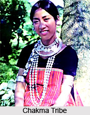
People belonging to Chakma, Lais, Pang, Tongchangya and Bawm tribes are the main inhabitants of the district and have vibrant cultural heritage. Major cultural dances of the district are Pawhlohtlawh, Sarlamkai, Nua Jhumo Naach, Biju Naach and Chawnglaizawnh. Buddhism and Christianity are the major religions of Lawngtlai District. Chakma, Lai and Tangchangya are the common languages prevailing in the district. Apart from these, other dialects of the district are Bawm, Bru and Pang. Folk culture is quite rich in the district with a number of folk tales prevailing in the society.


