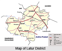
 Latur District is situated in the state of Maharashtra and covers a total area of 7,157 sq kms in the Deccan plateau. Latur district has an ancient historical background. The King `Amoghvarsha` of the Rashtrakutas dynasty developed the Latur city, originally the native place of the Rashtrakutas. The Rashtrakutas who succeeded the Chalukyas of Badami in 753 A.D called themselves the residents of Lattalut. It became one the districts of Maharashtra in 1960 as part of the district of Osmanabad. On August 15, 1982, Latur was separated from Osmanabad to form a separate district of Latur. The district is divided into three sub-divisions and 10 Talukas. The number of villages in Latur district according to the 2001 Census, is 943. Further details about the district are provided below.
Location of Latur District
Latur district is located in the south-eastern part of the state of Maharashtra. It is located between 17 degree 52 minutes north and 18 degree 50 minutes north latitude and 76 degrees 18 minutes east to 79 degrees 12 minutes east in the Deccan plateau. The district is situated on the Maharashtra-Karnataka boundary. On the eastern side of Latur is the Bidar district of Karnataka, whereas Nanded is on the northeast, Parbhani on the northern side, Beed district on the northwest and Osmanabad on the western and southern side. The entire district of Latur is situated on the Balaghat plateau, 540 to 638 metres above mean sea level.
History of Latur District
Latur has an ancient history. It was home to the Rashtrakutas dynasty and was part of Emperor Ashoka`s empire. It was, over the centuries, variously ruled by the Satavahana dynasty, the Sakas, the Chalukya dynasty, the Yadavas of Devagiri, the Delhi Sultans, the Bahamani dynasty of South India, Adil Shahi dynasty of Bijapur, and the Mughal dynasty. Later, in the 19th century, it became part of the independent princely state of Hyderabad. Earlier known as Naldurg tehsil, in 1905 it was merged with the surrounding areas and renamed Latur tehsil, and became part of Osmanabad district. After independence and the merger of Hyderabad with the Indian Union, Osmanabad became part of Bombay Province. In 1960, with the creation of Maharashtra, it became one of its districts. On August 15, 1982, Latur was separated from Osmanabad to form a separate district of Latur.
Geography of Latur District
The district may be divided into two regions - the Balaghat plateau, and the northeastern region consisting of Ahmadpur and Udgir. It covers a total area of 7,157 sq kms. The maximum temperature in the district is around 39.6 degree Celsius, whereas the minimum temperature hovers at around 13.9 degree Celsius. Average rainfall in the district stands at 802.4 mm. The main river flowing through the district is the Manjara River which flows on the Balaghat plateau along with its tributaries, the Terna River, Tawarja River and Gharni River. The other three tributaries of Manjara are Manyad, Teru and Lendi River which flow on the northern plains. The district is primarily agricultural and the major crops grown in the district are cereals, oilseeds, pulses, grapes.
Culture of Latur District
The major language spoken by the people in the district is the Marathi language, Urdu language, Telegu language, Kannada language, Hindi language, Gujarati language and Rajasthani language are also spoken. The preferred diet in the district includes rotis, rice, dal (pulses) and sabji (vegetables). Among the fairs held in the district, the Shri Siddeshwar fair at Latur is held every year. Thousands of people attend the Gangaram Maharaj Samadhi every Ekadashi at Hattibet in Udgir tehsil.
Getting there
Air: Latur is connected by air with Mumbai.
Rail: Latur is connected by rail. Direct trains are available for Mumbai and Hyderabad.
Road: State highways and roads from the district headquarters at Latur link all 10 tehsils (sub-districts) and major towns.


