Home > Indian History > Geography of India > Laknavaram Lake
Laknavaram Lake
Laknavaram Lake is one of the most impressive lake in Telangana that attracts a large number of tourists during autumn and winter seasons.

Share this Article:

Laknavaram Lake, Warangal District, TelanganaLaknavaram Lake or Laknavaram Cheruvu is a popular weekend destination in the Indian state of Telangana. This lake of natural beauty is the place for kayaking enthusiasts, funky boaters, wildlife discoverers and nature lovers.

This beautiful lake with mystic ambience lies within Laknavaram village in Govindaraopet Mandal. This lake is much closer to another Mandal called Mulug. It is at a distance of some 80 kilometres from Warangal District and some 190 kilometres from Hyderabad, which is now the capital city of both Telangana and Andhra Pradesh. The lake was said to have been discovered during the rule of Kakatiya dynasty in South India. It is beautifully wrapped up with thick forest trees with hills, coiled all round. Laknavaram Cheruvu or Laknavaram Lake is spread over some 10,000 acres acts as a water reservoir too.

Laknavaram Lake is around 78 km from Warangal District. It is about 7 km from Govindaraopet and 5 km from Chalvai. The tourists coming from Warangal District has to take the National Highway 202 road towards Mulugu. After crossing Mulugu, there will be a drive of 8 kilometres that leads one to Chalvai. This area is covered with thick forests.

The evergreen hills of Govindaraopet lie side by side to form a massive bowl like structure. It holds the spacious, beautiful and pristine lake popular known as Laknavaram Cheruvu.

Laknavaram Cheruvu was spotted as the excellent place amidst trees and green hills lined up around to hold the rainwater. The King Ganapathi Devudu only built a small sluice gate turning the place into a spacious lake which now feeds thousands of acres of agricultural land every year.

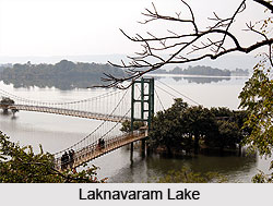
Lakhnavaram Lake or Laknavaram Cheruvu is an idyllic holiday-maker spot of Warangal District in Telangana. It is ensconced between the huge Govindaraopet Mountains the Laknavaram Lake is sprawled over an area of 10,000 acres. It covers around thirteen beautiful islands floating in its serene waters, two of which are connected with a hanging bridge. It is an addition by the Telangana State Tourism Department in its attempt to enhance the value of the place as a weekend tourist destination. Telangana State Tourism Department has several other plans to make this place as an ideal tourist destination among the foreign tourists. However, it is also a hot place for picnic. Tourists can enjoy this place while seeking peace and calm. Located in isolated surroundings, the lake is far away from the hustle and bustle of city life and affords tourists with the peace of mind they crave for in their everyday urban life.


Share this Article:

Related Articles

More Articles in Geography of India


Geography of Uttar Pradesh
The fourth largest State in India UP is located in the Northern part of India whose area is 2,36,286 sq Kms.
Geography of Maharashtra
Covering an area of 308,000 sq. km, Maharashtra, the third largest state in India.
Geography of Kerala
Geography of Kerala includes plains, hills, valleys and coasts. With the Arabian Sea in the west, the Western Ghats in the east and networked by several rivers, Kerala enjoys diverse geographical features.
Geography of West Bengal
The geography of West Bengal is unique with high peaks of the Himalayan range in the north, the Bay of Bengal in the south and the remaining region is covered with both plains and plateaus.
Geography of Jharkhand
Geography of Jharkhand is comprised of the rich mineral resources and the highly agricultural prospect in this state.
Geography of Sikkim
Geography of Sikkim is characterised by a vast array of magnificent hillock that extends from one corner of the state to the other.
Geography of Meghalaya
The suitable climate, highland plateaus, rivers and the flora and fauna together forms the geography of Meghalaya.
Geography of Mizoram
Mizoram is surrounded by hills, valleys, rivers, waterfalls and lakes. The hills range from 1000 meters to 2000 meters. Rivers, lakes and waterfalls also play major role in forming the land of Mizoram.
Geography of Jammu & Kashmir
Jammu and Kashmir is encompassed by valleys. Some of the dominant valleys of the state are Kashmir Valley, Tawi Valley, Chenab Valley, Poonch Valley, Sind Valley and Lidder Valley etc. Jhelum River is the only major Himalayan River which flows through the Kashmir valley. Indus, Tawi, Ravi and Chenab Rivers are the major ones flowing through the region.
Geography of Daman and Diu
Daman and Diu is situated on the west coast of India and are the smallest union territories of India.
Geography of Goa
Geography of Goa occupies a prime location along the Konkan coastal belt on the western coast of India. The state is bordered by Maharashtra in the north and Karnataka in the south. The Western Ghats in the east contribute to the flora and fauna of Goa.
Geography of Arunachal Pradesh
Geography of Arunachal Pradesh reveals that it is a hilly tract nestled in the foot of Himalayas.
Geography of Kutch
Geography of Kutch District is covering an area of 45,612 km. Kutch District is the largest district in the state of Gujarat.
Geography of Ladakh
Geography of Ladakh mainly comprises the huge Karakoram Range with long stretch of cold desert which mark the region separately from the rest of the states of Indian subcontinent. Surrounded with the mountain ranges from all corners this small region separates Indian subcontinent from rest of the Asian continent.
Geography of Rajasthan
Geography of Rajasthan defines the dry topography with arid climate of the western mountain region.
Geography of Tamil Nadu
The Indian state of Tamil Nadu is located in the Northern hemisphere in the hot zone.