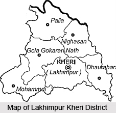
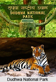
 Lakhimpur Kheri district is situated in the Lucknow division of the state of Uttar Pradesh and the district is located along the border with Nepal. Lakhimpur Kheri District is headquartered in Lakhimpur city. Lakhimpur Kheri district is the largest district in Uttar Pradesh in terms of area and consists of a total area of 7680 sq km. It is a part of the Lucknow division. As per the Government of India, it is one of the Minority Concentrated Districts in the country according to the 2001 census data on socio-economic indicators, population and basic amenities indicators. The district is well known for Dudhwa National Park and Arpan Kakkar. Dudhwa National Park is the only national park in the state of Uttar Pradesh. Various types of rare and endangered species such as leopard, tiger, hispid hare, swamp deer, Bengal florican and others are found here. Lakhimpur Kheri district is pregnant with natural resources and is nestled amidst lush green vegetation and several rivers.
History of Lakhimpur Kheri District
Lakhimpur Kheri district was originally named Luxmipur. In the ancient period, the region was covered with Acacia catechu Wild trees, locally known as Khair. Thus the name Lakhimpur Kheri was adopted. Kheri is a town near Lakhimpur. The northern region of Lakhimpur Kheri was under the Rajputs during the 10th century and they eventually evicted the Pasis and other aboriginal tribes. The Muslim rule gradually spread to the region and during the 14th century a chain of forts were established along the northern border to prevent the invasion of the Sarkar of Khairabad in the Subah of Oudh.
After Rohilkhand was surrendered to the British in the year 1801, part of Lakhimpur Kheri District was included in the cession. After the Anglo- Nepalese War of 1814-1816, it was restored to Oudh. On the annexation of Oudh in the year 1856, the west of the region was formed into a District known as Mohmmadi and cast into Mallanpur. The British officials eventually escaped to Nepal and most of them died. Peace was finally restored in the year 1859. The head-quarter of the District was moved to Lakhimpur later.
Geography of Lakhimpur Kheri District
The geographical co-ordinates of Lakhimpur Kheri district are Latitude 27.6 to 28.6 (North) and Longitude 80.34 to 81.30 (East). The district shares its border with Nepal in the north, Hardoi and Sitapur district in south, Pilibhit and Shahjahanpur districts in west, and Bahraich district in east. The region is drained by many rivers such as Ghagra, Koriyala, Chauka, Gomti, Saryu, Mohana, Sharda, Ull, Sarayan and Kathana.
The climate in Lakhimpur Kheri district is usually hot throughout the year, except for the monsoon season. Winter is very cold and fog is a common feature. The temperature in summer (March to June) ranges from 43 degree Celsius to 20 degree Celsius. The winter temperature is between 30 degree Celsius and 4 degree Celsius, from October to February. Average annual rainfall is around 1093 mm.

Demography of Lakhimpur Kheri District
As per the 2011 census, Lakhimpur Kheri District consists of a population of 4,013,634. It is ranked at 56th out of a total of 640 in India. The population density of the district is 523 inhabitants per sq km. over the decade 2001-2011 the population growth rate was 25.14 %. Gender ration of Lakhimpur Kheri is 887 females for every 1000 males and has a literacy rate of 62.71 %.
Culture of Lakhimpur Kheri District
The local language, which is generally spoken here, includes Awadhi which is a vernacular in the Hindi-Urdu continuum. Hinduism is the dominant religion with of almost 77.41% of the population being Hindus. Other religions include Islam and Sikhism.
Education of Lakhimpur Kheri District
Education is one of the main priorities of Lakhimpur Kheri District. There are several schools, colleges and other institutes in the region namely, St. Don Bosco`s College, Dharm Sabha Inter college, B.P.S. Public School, Lucknow Public School, C.B. Singh Gaur Memorial School, Cane Growers Inter College, Pt. Deen Dayal Upadhyaya Saraswati Vidya Mandir Inter College, Govt Girls` Inter college, City Montessori Kheri, Ajmani International School, Lucknow Public School, Yuvraj Dutt College, Government Inter College, Saraswati Vidya Mandir, Paul International School, St. John`s School in Gola Gokarannath, Kunwar Khuswaqt Rai, Adarsh Vidya Mandir, Greenfield Academy, Children`s Academy and Arya Kanya.
Economy of Lakhimpur Kheri District
Agriculture is the primary occupation for the people of Lakhimpur Kheri District. The sugar cane industry is well developed in the region and satisfies a huge part of the world`s sugar demands. The dominating industry in the district is the sugar industry. There are many big integrated sugar mills as well as small plants. Lakhimpur Kheri also has several private, government and co-operative sugar mills Steel Authority of India Limited (SAIL) is setting up a steel processing unit here.
Being one of the most backward districts in Uttar Pradesh, Lakhimpur Kheri receives funds from the Backward Regions Grant Fund Programme (BRGF).
Tourism of Lakhimpur Kheri District
Lakhimpur Kheri District is one of the most popular tourist destinations in India as the Dudhwa Tiger Reserve is located in the region. The Dudhwa Tiger Reserve has two core areas, Dudhwa National Park and Kishanpur Wildlife Sanctuary, which were united in the year 1987. Dudhwa National Park is the first National Park in the state of Uttar Pradesh. Sharda Dam, Naseeruddin Memorial Hall and Deer Park are other chief tourist attractions of Lakhimpur Kheri.
There are some religious pilgrimage sites that are very popular amongst the devotees, like Eid Gaah, Shiva Temple Gola Gokaran Nath, Frog Temple, Shiva Temple Lilauti Nath and Shiva Temple Devkali.


