 The state of Sikkim is located in the north eastern part of India. The geographical terrain of this state is characterized by mountains, glaciers, hot springs, rivers and streams. They not only beautify this state but also draw a plethora of tourists. Lakes in Sikkim are no exception in this regard. They also have the potential to attract the attention of tourists visiting this state.
Chomalu Lake
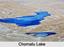
Chomalu Lake is situated in North Sikkim district. This lake has the distinction of being the highest lake in India with an elevation of about 5330 meters and the 14th highest lake in the world. This glacial freshwater lake serves as a major source of Lachen Chhu River. The luculent water of this lake flows on the plateau that extends from Sikkim to Tibet. This lake is visited by migratory bird species from other parts of India, China and Russia.
Gurudongmar Lake
Gurudongmar Lake is located in North Sikkim. This fresh-water lake has the distinction of being the second highest lake in Sikkim as well as in India with an elevation of about 17,800 ft. Glaciers form the source of this lake. The lake in turn serves as one of the sources of River Teesta. Gurudongmar Lake has surface area of about 118 hectares, surface elevation of about 17,004 ft and shore length of about 5.34 kilometers. Gurudongmar Lake once had luculent icy water, with even the bed of the lake being visible from the surface. Unfortunately, local pollution has resulted in white color appearance of the lake.
Tsomgo Lake
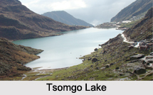
Tsomgo Lake is located about 35 km from Gangtok in East Sikkim at an altitude of about 3,753 m. This oval shaped glacial lake has water with moderate turbidity. It has maximum length of about 836 meters maximum width of about 427 meters and maximum depth of about 15 meters. This lake is a tourism product of Sikkim due to rides on yaks and mules and celebration of Guru Purnima festival at the lake site.
Khecheopalri Lake
Khecheopalri Lake is situated about 34 kilometers to the northwest of the town of Pelling. Two perennial and five seasonal stream inlets form the source of this lake. This lake has a catchment area of about 12 square kilometers, surface area of about 3.79 hectares, surface elevation of about 1,700 m, average depth of about 7.2 m and water volume of about 272,880 cubic meters. This lake serves as a home to aquatic faunal and avifaunal species.
Other Lakes in Sikkim
Green Lake, Lake Menmecho, Lakshmi Pokhari Lake and Kathok Lake are some of the other Lakes in Sikkim.


