 The state of Andhra Pradesh is located in the southern part of India. This state has beaches, hills and valleys, caves, wildlife, forests, pilgrimage sites, etc. They have not only beautified this state but have also made Andhra Pradesh one of the famous tourist destinations of India. Lakes in Andhra Pradesh are no exception in this regard. They too act as tourism products of Andhra Pradesh, which is also called Koh-i-Noor of India.
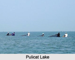
Pulicat Lake
Over 96% of Pulicat Lake is located in Nellore in Andhra Pradesh on the Coromandal Coast. It has the distinction of being the second largest brackish water lake or lagoon in India, after Chilka Lake. It has maximum length of about 60 km, maximum width of about 17.5 km, surface area of about 250-450 square kilometers and average depth of about 1 m. This lake is separated from the Bay of Bengal by the barrier island of Sriharikota. Arani River, Kalangi River and Swarnamukhi River are the source of this lake, whereas its outlet is Bay of Bengal. Pulicat Lake in Andhra Pradesh is threatened by pollution from sewage, pesticides, agricultural chemicals and industrial effluents.
Kolleru Lake
 Kolleru Lake is located about 15 kilometers away from the city of Eluru. More specifically, it is spread across the West Godavari and Krishna districts of Andhra Pradesh. This lake is also known as the "Peerless Fisherman"s Paradise and Bird Heaven". It is considered to be one of the largest fresh water lakes in India and the largest freshwater lake in Andhra Pradesh. Characteristically, it is a shallow lake. This lake spreads over an area of about 308 sq. km and expands up to 954 sq km at the highest flood level. The Budameru, Tammileru, Yerra Kalva and Ramileru rivers drain their waters in this lake.
Kolleru Lake today faces problems like illegal encroachments, loss of ecological diversity and intrusion of sea water into the land masses and its fallout in terms of adverse influence on the rainfall pattern in this region. In November 1999, this lake was declared as a wildlife sanctuary under India`s Wildlife Protection Act of 1972. Sri Peddinti Ammavari Temple is one of the oldest and famous temples found in Kolleru.
Kolleru Lake is located about 15 kilometers away from the city of Eluru. More specifically, it is spread across the West Godavari and Krishna districts of Andhra Pradesh. This lake is also known as the "Peerless Fisherman"s Paradise and Bird Heaven". It is considered to be one of the largest fresh water lakes in India and the largest freshwater lake in Andhra Pradesh. Characteristically, it is a shallow lake. This lake spreads over an area of about 308 sq. km and expands up to 954 sq km at the highest flood level. The Budameru, Tammileru, Yerra Kalva and Ramileru rivers drain their waters in this lake.
Kolleru Lake today faces problems like illegal encroachments, loss of ecological diversity and intrusion of sea water into the land masses and its fallout in terms of adverse influence on the rainfall pattern in this region. In November 1999, this lake was declared as a wildlife sanctuary under India`s Wildlife Protection Act of 1972. Sri Peddinti Ammavari Temple is one of the oldest and famous temples found in Kolleru.
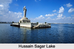
Hussain Sagar Lake
Hussain Sagar is a lake located in Hyderabad. It is also known as the Tank Bund. This lake separates Hyderabad from its twin city Secunderabad. A special feature of this lake is a large monolithic statue of Gautama Buddha carved on an island in the middle of the lake, in 1992. This statue is 16 m tall and weighs 350 tonnes. Characteristically, it is an artificial lake that stores water perennially fed by canals from River Musi.


