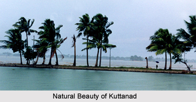
 Kuttanad is a region in the Alappuzha district, in the Indian state of Kerala, popular for its charmingly enormous paddy fields and its geographical peculiarities. It is the region having lowest altitude in India, and one of the few places in the world where farming is carried out below sea level. It is also one of the historically important places in the ancient history of South India.
History of Kuttanad
Kuttanad does not have any recorded history attached to it. However, the local history, transferred from generation, is a blend of legends and myths. There is significant reference to Kuttanad in the Indian epic Mahabharata. The five Pandavas, during their exile, are said to have travelled through this land. During those days, Kuttanad was part of a dense forest, later destroyed by a forest fire which is also mentioned in the epic. Thus, it was named as Chuttanad or the burnt place. In course of time Chuttanad became Kuttanad. One can still view coal or Kari if dug deep into the soil of Kuttanad, pointing to the fact that the place was once a forest, destroyed by wild fire. The names of places, in most cases, end in Kari. Some of the names of place that are familiar are Ramankary, Puthukkary, Oorukkary, Mitrakkary, Mampuzhakkary, Kainakari, Chathurthiakary and Chennamkari. It is also said that Kuttanad was once under the sea.
During the supremacy of Chera Dynasty, which ruled over ancient Kerala, attained an important place in history. One of the powerful kings in the dynasty: Cheran Chenguttavan is said to have ruled his vast kingdom from Kuttanad, when it was also a famous centre of Buddhism. There is another version for its place name. The Buddhist centre Buddhanad later became Kuttanad.
Divisions of Kuttanad
The Kuttanad region is broadly classified into three divisions: Lower Kuttanad, Upper Kuttanad and North Kuttanad.
Lower Kuttanad comprises taluks of Ambalapuzha taluk, Kuttanad (excluding Edathua, Thalavady and Muttar, and the northern half of Karthikapally Taluk in Alappuzha District).
Upper Kuttanad comprises Veeyapuram village in Karthikapally taluk, Edathua, Thalavady, Kidangara and Muttar in Kuttanad taluk; Chennithala village in Mavelikkara Taluk, Mannar, Kuruttissery, Budhanur, Ennakkad villages in Chengannur taluk of Alappuzha district; and Parumala, Kadapra, Niranam, Pulikeezhu, Peringara, Chathenkeri, Nedumpuram, villages of Thiruvalla taluk in Pathanamthitta district.
North Kuttanad includes Vaikom Taluk, western parts of Kottayam Taluk, and western parts of Changanacherry Taluk in Kottayam District.
Villages of Kuttanad
A few of the chief villages that form Kuttanad are: Kainakary, Ramankary, Niramom, Kaipuzha, Kumarakom, Puthukkary, Chennamkary, Nedumudi, Edathua, Mampuzhakkary, Kavalam, Pulincunnoo, Kannady, Neelamperoor, Kainady, Veliyanadu, Veeyapuram, Kumaramkary, Valady, Vezhapra, Kunnamkary, Kidangara, Mithrakary, Thalavadi, Changankary, Muttar, Neerattupuram, Champakulam, Nedumudi, Payippad, Karichal, Moonnatummukham, Melpadom, Ayaparambu, Anary, Pandi, Pacha, Cheruthana, Vellamkulangara, Pilappuzha, Karuvatta, Chennithala, Kayalppuram, Mankompu, Narakathara, Venattukad, Chathurthiakary, Manalady, Koduppunna, Thayankarry and Pullangadi among others.
