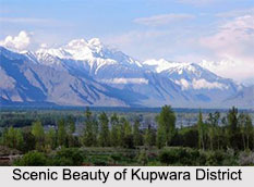
 Kupwara District is situated in the state of Jammu and Kashmir. Dark forests and rich wild life make it noteworthy from tourism and wildlife point of view. Kupwara District was carved out form erstwhile Baramulla District in the year 1979. Nature has been very kind to Kupwara.
Location of Kupwara District
Kupwara is the district Headquarter "Kupwara". It is situated at a distance of 90 kilometres from the summer capital of state, i.e. Srinagar.
History of Kupwara District
There is no written evidence why the district is known as Kupwara. However there are some legends about it. It is believed that there was a hut, constructed by somebody in the nearby jungle which known as Kopar, because accidents often took place there. It is also said that the famous saint, Zaiti Shah Wali called the habitation Ko-pore (people of bad reputation) because the children of this habitation used to throw stones on him when he passed through it. It is further believed that the famous Saint Syed Mohammad Gabi, whose tomb is in the heart of Kupwara, called it Kuferwari (the place of non-believers). Later on he converted the people to Islam by his preaching, thus Kupwara is the modified and changed name of Ko-por or Kuferwari.
Geography of Kupwara District
Kupwara district is situated in the extreme north-west of Kashmir valley. Its northern and western borders form the line of control between India and Pakistan and eastern and southern borders touch Sopore, Bandipore and Baramulla Tehsils. Famous river Kishan Ganga separates Pakistan occupied Kashmir and Jammu and Kashmir in Machil, Keran and Teetwal areas. Kupwara district is situated at an average altitude of 5300 feet from the sea level. The geographical area of the District is 2379 sq kms. Kupwara district is located between 34.17 degree to 34.21 degree East latitude and 73.10 degree to 73.16 degree north longitude.
Demography of Kupwara District
Kupwara District had a population of 14,711. The males constitute 61percent of the population and females 39 percent. Kupwara has an average literacy rate of 55percent which is lower than the national average of 59.5 percent.
Administration of Kupwara District
Kupwara district has three tehsils which are Handwara, Karnah and Kupwara. This district consists of eleven blocks namely Sogam, Langate, Wavoora, Ramhal, Kupwara, Rajwal, Tangdar, Teetwal, Kralpora, Trehgam and Kalaroo. Each block consists of a number of panchayats.
Education of Kupwara District
Kupwara district has a literacy rate of 50.50 percent. The district has got around 4 colleges, 22 Higher Secondary Schools and 1289 educational institutions. Government Degree College in Kupwara is the largest college in the district with total enrolment exceeding 3000.
Tourism in Kupwara District
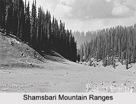
Kupwara district offers a lot when it comes to tourism. The district is located between Pir panjal and Shamsbari mountain ranges surrounded by snow clad mountains and dense green forests. Lolab Valley, Seemab valley and Bangrus Valley are the popular tourist attraction here. Ainch is 1100 feet High Mountain which also falls in Kajinag range. In its eastern lap lie the beautiful villages of Fulmarg, Hachmerg, Tumna, Hafrada etc. Dajalongun Mountain is situated in POK and visible in North West part of the district and always remains snow clad and mostly hidden in clouds. Feshiltong Mountain is also in the north west of Kupwara, and contains historical pass of Lashdut and meadow of Gogalneur lies across it. Babace Gully is a well known mountain pass which connects Nowgam with Baramullah. Farkiyan Gully is a historical pass that joins the valley with Keran and Drawa areas. On reaching Keran one can closely observe the most beautiful Neelam valley across the Kishan Ganga. Ainch Behak is a cluster of meadows, located in Ainch Mountain in the west of Ramhall area. There is a shrine, known as Char Yar, in the meadows.
Related Articles
Jammu and Kashmir
Districts of Jammu and Kashmir
Baramulla district
Pir Panjal Range
Culture of Jammu and Kashmir


