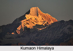
 Kumaon Himalayas recline next to the region of Garhwal region. They are actually situated on the Great Himalayan Range. Kumaon is often confused with the other parts of Garhwal; in fact there is no official border to demarcate the region. This region of the Himalaya Mountains consists of the three popular hill districts of Almorah, Nainital and Pithoragarh. Terai to the south and Tibet lies to the north. Its eastern boundary runs along the Kali River which separates India from the neighboring country Nepal. The tributaries, Kuthi, Darma and Lassar, flow into the Kali River at different points. The Kali valley was once the standard trade route from India into Tibet over the Lipu Lekh pass. The Kuthi emerges from Jolingkong Lake, as beautiful a spot as any, while other passes of Mangsha Dhura and Lampiya Dhura are not far away. Sangthang (6480 m) is the only peak known to have been climbed in this section.
The Panchchuli massif has five summits. It forms the barrier between the Darma and Gori valleys. The summits are numbered north to south. Peak II at 6904 m is the highest. They were earlier attempted from the Sona and Meola glaciers in the east. Finally the Indo-Tibet Border Police opened the route in the year 1972 and made the first ascent in the year 1973 from the west. The area is plastered with smaller peaks such as Nagling (6042 m). Moreover, the Gori valley has some excellent climbing prospects, too. The portion of Gori valley from Munsiary to Milam is known as Johar, a form of grain that is harvested in the non-trading season. A solid stone track leads over the Unta Dhura pass towards Tibet. At the head of this valley stand Hardeol (7151 m) and Tirsuli (7074 m) which have attracted many parties. At the eastern end of the Kumaon Himalayan region lie Nanda Pal (6306 m), Nanda Gond (6315 m), Nital Thaur (6236 m) and Kalganga Dhura (6215 m) - each with enough technical difficulty to match its beauty. So far, only Nanda Pal has been climbed.
To the west of the Kumaon Himalayan region stand the peaks of the Nanda Devi Sanctuary. Danpur is the western region of Kumaon, so named from the generosity of its people (the term `Dan` means gift). The area comprises the two major valleys of Pindari and Sun-derdhunga. The Pindari glacier ends at Traiu`s Pass at its head, with the peaks of Nanda Khat or Bed of Nanda (6611 m), to its north and Nanda Kot to its south. To the south of Pindari is the Kafni glacier at the head of which nestle the peaks of Nandabhanar (6236 m) and Nandakhani (6029 m). Panwali Dwar, Gateway of Winds, (6663 m) is a beautiful peak on the outer wall of the Nanda Devi Sanctuary, separating the Pindari from the Sunderdhunga. Shipton and Tilman descended by the pass at its head from the Sanctuary in 1934. Adjoining the Sunderdhunga valley is the Bidalgwar glacier which affords a southern approach to the Trisul massif. The southern aspects of the Kumaon Himalaya offer a lot of interesting exploring options to the climbers.


