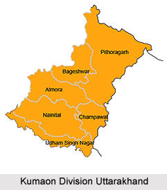
 Kumaon Division mainly categorised into eight diverse princely states i.e., Baijnath-Katyuri, Dwarhat, Doti, Baramandal, Askot, Sira, Sora, Sui (Kali kumaon). Later on, in 1581 AD after the defeat of Raika Hari Mall (maternal uncle of Rudra chand) with the hand of Rudra Chand all these disintegrated parts came under King Rudra chand and the whole region was as kumaon. Kumaon is one of the two regions and administrative sectors of Uttarakhand, a hilly state in North India, the other one being the Garwal Division. It comprises of the districts of Almora, Champawat, Nainital, Pithoragarh, and Udham Singh Nagar. It is bordered by Tibet in the north, Nepal in the east. On the south is the state of Uttar Pradesh and on the west is the Garwal region. The people of the region are known as Kumaonis and they speak Kumaoni language. The place is also known for the army regiment known as the Kumaoni Regiment.
Important towns of Kumaon are Almora, Pithoragarh, Haldwani, Nainital, Rudrapur, Mukteshwar Kashipur, Pantnagar, and Ranikhet. Nainital happens to be the administrative centre of Kumaon Division and this is where the Uttarakhand high court is situated.
Geography of Kumaon Division
The Kumaon Region consists of massive Himalayan tract along with the two submontane strips known as the Terai and the Bhabhar. The place was impenetrable forest till 1850. But after 1850 there were numerous clearings which attracted large population from the hills who indulged in agriculture and cultivation.
The rivers like Dhauli, Gori, and Kali etc go up chiefly in the southern slope of the Tibetan watershed north of the loftiest peaks, amongst which they make their way down valleys of rapid declivity and extraordinary depth. The main are the Pindari, the Sharda (Kali), and Kailganga, whose waters join the Alaknanda. The river Sharda (Kali) forms the international border between Nepal and India.
The primary trees that are grown in the area are Chir Pine, Pindrow Fir, Alder, Sal, Himalayan Cypress and Saindan.
Some of the important dynasties that ruled the place are Katyuri Raj, Chand Raj, Raikas of Doti, Gorkha Rule and the British Raj.
 Martial Race of Kumaon Division
Kumaoni people are famous for their valour and courage. Their honour is legendary. They were never been completely subjected to the dominant and powerful Muslim Rule of Delhi.
It is indeed interesting to note here that the 3rd Gorkha Rifles was known as the Keemaon battalion when it was formed and it included Kumaonis as well as the Garhwalis along with the Gorkhas. The Kumaonis, once accepted as a martial race, were themselves to be recruited in the Hyderabad regiment and displace the native troops, eventually after Independence of India became the Kumaon Regiment. The Kumaon Regiment is known for their tremendous courage and is one of the most decorated regiments of the Indian Army.
Language of the Kumaoni People
Amongst its dialects, the Central Kumauni is spoken in Almora and northern Nainital, North-eastern Kumauni is in Pithoragarh, South-eastern Kumauni is in South-eastern Nainital, and Western Kumauni is west of Almora and Nainital. All together there are 20 dialects spoken in the Kumaon region, namely, Askoti, Sirali, Johari, Majh Kumaiya, Danpuriya, Soryali, Gangoli, Khasparjia, Chaugarkhyali, Kumaiya, Phaldakoti, Pachhai, and Rauchaubhaisi.
Dialects of Kumaoni Language
* Kali Kumaon, Central Kumaoni
* North-Eastern Kumaoni
* South-Eastern Kumaoni
* Western Kumaoni
* Askoti of Askot
* Bhabhri of Ramnagar
* Chaugarkhiyali of Chaugarkha
* Danpuriya of Danpur
* Gangoli of Ganai-Gangoli (Gangolihat)
* Johari of Malla and Talla Johar
* Khasparjiya of Almora
* Kumaiyya of Champawat
* Pachhai of Pali-Pachhhau (Ranikhet, Dwarahat)
* Pashchimi
* Phaldakotiya of Phaldkot
* Rhau-Chaubyansi, (Nainital)
* Sirali of Sirakot (Didihat)
* Soriyali of Sor Valley (Pithoragarh)
* Baitada of Baitadi , Darchula and parts of Bajhang District in Nepal
* Dotiyali of Doti


