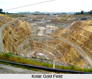
 Gold was first mined in the area around Kolar Gold Fields in the 2nd and 3rd century AD. This town is around 22 kms, east of Bengaluru. It was once the pride of Mysore. This gold mine produced a sizeable amount of gold during the days of the British Raj. In the ninth and tenth century during the Chola period, the volume of operation grew. However large-scale mining came in 1850s under British with more manpower and urbane machinery. In the year 2001 gold mines of Kolar Gold fields were closed down by due to reducing deposits and increasing costs.
The resources under the ground are around three million tonnes of low quality gold according to experts. Gold mining started in the first millennium BC. The Champion reef was mined to a depth of 50 m during the rule of the Gupta in the fifth century A.D. Metal was mined during the Chola period, the Vijayanagar Empire and later by Tipu Sultan. In the beginning of the nineteenth century again digging was renewed in the Kolar Goldfields. Large-scale mining came in the 1850s under the British John Taylor & Company.
The principal Mines in the Gold Fields started with Michael F. Lavelle in 1864 to the mines developed by John Taylor & Company were: Mysore Gold Mine, Champion Reef Mine, Oorgaum Mine, Tank Block Mine, Balaghat Mine, Coromandel Mine, Oriental Mine, Nine Reefs Mine, Road Block Mine and Nundydroog Mine.
Around three hundred thousand people lived in the Kolar Gold Fields. The population is mainly Tamil speaking. There are also Telegu and Kannada language speakers. Kolar Gold fields have an Engineering College. It is Dr. T. Thimmaiah Institute of Technology, a Dental College which is KGF College of Dental Science & Hospital, a Law College and several schools. It also has the National Institute of Rock Mechanics which is run by the Ministry of Mines with the help of GSI and IBM.
Kolar Gold Fields was known as "Little England" by the Britishers due to its temperate weather and a beautiful landscape. There are still many old British styled bungalows thereby giving a glimpse of the British culture. The city is located on the Deccan Plateau approximately 3000 feet above sea level.


